IMAGES TAKEN NEAR TO
Throstlenest Avenue, DARLINGTON, DL1 2BH
Introduction
This page details the photographs taken nearby to Throstlenest Avenue, DL1 2BH by members of the Geograph project.
The Geograph project started in 2005 with the aim of publishing, organising and preserving representative images for every square kilometre of Great Britain, Ireland and the Isle of Man.

There are currently over 7.5m images from over14,400 individuals and you can help contribute to the project by visiting https://www.geograph.org.uk
Image Map
Images are licensed for reuse under creativecommons.org/licenses/by-sa/2.0
Notes
- Clicking on the map will re-center to the selected point.
- The higher the marker number, the further away the image location is from the centre of the postcode.
Image Listing (17 Images Found)
Images are licensed for reuse under creativecommons.org/licenses/by-sa/2.0
Image
Details
Distance
1

Ready-mix concrete plant
Belonging to Lafarge.
Image: © Mick Garratt
Taken: 29 Mar 2007
0.06 miles
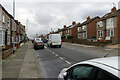
5
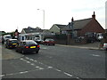
Haughton Road, Darlington.
Looking west along Haughton Road towards D.T. McKenzie and Central Park Car Sales on the 11th September 2006.
Image: © Philip Soakell
Taken: 11 Sep 2006
0.18 miles
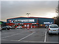
6
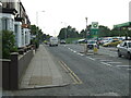
Haughton Road, Darlington
Looking west along Haughton Road towards the road junction with Barton Street on the 11th September 2006, showing the BP service station and Skoda car dealership.
Taken prior to the construction of the Darlington Eastern Corridor Road Link.
Image: © Philip Soakell
Taken: 11 Sep 2006
0.20 miles
7
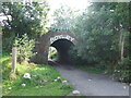
Former Railway Bridge on the route of original Stockton to Darlington Railway.
Railway bridge as viewed on the 11th September 2006 prior to the construction of the Darlington Eastern Corridor link road, which followed the route of the original railway used by Stephenson's Rocket.
Image: © Philip Soakell
Taken: 11 Sep 2006
0.21 miles
8
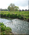
Riffle in the River Skerne
The River Skerne, here seen flowing towards central Darlington, passing through meadows in Haughton Le Skerne, has been the subject of much environmental improvement, especially downstream, where it used to be heavily polluted. The water here is relatively clean for an industrial area, and wild flowers populate the banks as it traverses the suburbs.
Image: © Andy Waddington
Taken: 23 Apr 2014
0.22 miles
9
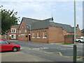
Barton Street, Darlington.
St. William & St. Francis De Sales R.C. Church, 11th September 2006.
Image: © Philip Soakell
Taken: 11 Sep 2006
0.22 miles