IMAGES TAKEN NEAR TO
Tees View, BARNARD CASTLE, DL12 9RN
Introduction
This page details the photographs taken nearby to Tees View, DL12 9RN by members of the Geograph project.
The Geograph project started in 2005 with the aim of publishing, organising and preserving representative images for every square kilometre of Great Britain, Ireland and the Isle of Man.

There are currently over 7.5m images from over14,400 individuals and you can help contribute to the project by visiting https://www.geograph.org.uk
Image Map
Images are licensed for reuse under creativecommons.org/licenses/by-sa/2.0
Notes
- Clicking on the map will re-center to the selected point.
- The higher the marker number, the further away the image location is from the centre of the postcode.
Image Listing (79 Images Found)
Images are licensed for reuse under creativecommons.org/licenses/by-sa/2.0
Image
Details
Distance
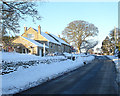
3
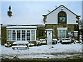
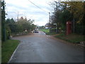
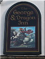
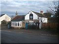
The George and Dragon, Boldron
Boldron's only pub, much used by the local and visiting quoits teams, on the corner site where West Lane (the main east-west in the village where most houses are situated) and Startforth Lane (off to the left) which heads down to Barnard Castle. The pub also used to house the tiny Post Office before the previous landlady retired and took that off to a house in the main part of the village. Even the relocated Post Office had gone by the time of this photo (it closed in 2009). The pub didn't last that much longer (it is now a private house) but quite a lot of the bar fittings and furniture were recycled into the Pinfold Club, which opened as a community-run village drinking hub in the old Primitive Methodist Chapel.
Image: © Andy Waddington
Taken: 5 Jan 2010
0.03 miles
5
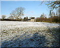
Hill House
Looking from the eastern edge of the eastern of two fields behind Hill House Farm. Yet another sprinkling of overnight snow makes the muddy field look quite pleasant, but the sun will soon melt this again, as the ground is not remotely frozen. The trees in the distance on the right are in the garden of Hilltop Cottage.
Image: © Andy Waddington
Taken: 9 Feb 2010
0.05 miles
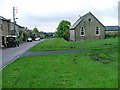
6
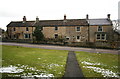
Boldron House and Newton Cottage
Directly opposite Boldron parish church (whose path is in the foreground across the green), these two houses have been assembled "piecemeal" at different times, but maintaining a surprisingly level roofline compared with other houses further down the village.
Image: © Andy Waddington
Taken: 27 Feb 2010
0.05 miles
7
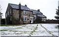
Hilltop Cottage
It's not much of a hill, but Hilltop Cottage is at the highest point of the Boldron village green, which slopes down to the road (on which the photographer was standing) and down the length of the village to the left. This fall of snow is pretty soggy and rapidly disappearing, so the slalom poles have been taken away and the local children are not bothering to sledge on it - they've been spoilt throughout December and January !
Image: © Andy Waddington
Taken: 26 Feb 2010
0.05 miles
8
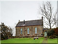
Former Boldron Mission Chapel
There's surprisingly little change in the external appearance of what we always thought of as the Parish Church in Boldron since it was sold by the Church of England in 2012 and has subsequently been converted into a residence. I presume the internal changes are more significant - I certainly hope it has better heating ! Built in the 1880's on the site of a former house previously occupied by Jonathan Clarkson from 1841, with much of the building stone recycled from
that house. It was an "outreach" from the mother church in Startforth (in the parish of Startforth and Rokeby with Brignall). The civil parish of Boldron, as shown on recent maps, is a small fraction of the area of that bigger entity, but does extend west from the village to take in the hamlet of Thornberry. This view is from the green at Boldron, which lies between the public road and the former chapel.
Image: © Andy Waddington
Taken: 3 Dec 2021
0.05 miles
9
Kilgarth and South Wood
These two houses, on the south side of the road through Boldron, were clearly built as a pair. This is at the west end of the main built-up part of the village, and beyond the junction farm houses lie more scattered among the fields. The low light from the east indicates the start of a bright but cold winter morning, with icy roads - we are right at the end of the list for the gritters here, and they rarely visit the dead-end road behind the photographer at all.
Image: © Andy Waddington
Taken: 4 Jan 2010
0.06 miles
10
Boldron Green and Methodist Church
For further info about the history of the village see https://boldron-history.co.uk/
Image: © Mick Garratt
Taken: 19 Oct 2005
0.06 miles