IMAGES TAKEN NEAR TO
High Startforth, BARNARD CASTLE, DL12 9RA
Introduction
This page details the photographs taken nearby to DL12 9RA by members of the Geograph project.
The Geograph project started in 2005 with the aim of publishing, organising and preserving representative images for every square kilometre of Great Britain, Ireland and the Isle of Man.

There are currently over 7.5m images from over14,400 individuals and you can help contribute to the project by visiting https://www.geograph.org.uk
Image Map
Images are licensed for reuse under creativecommons.org/licenses/by-sa/2.0
Notes
- Clicking on the map will re-center to the selected point.
- The higher the marker number, the further away the image location is from the centre of the postcode.
Image Listing (6 Images Found)
Images are licensed for reuse under creativecommons.org/licenses/by-sa/2.0
Image
Details
Distance
1

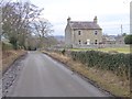
Startforth Hall Farm
Startforth Hall Farm above Startforth village.
Image: © Peter McDermott
Taken: 8 Sep 2012
0.01 miles
2
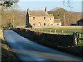
Startforth Hall Farm
Traditional stone built farmhouse off Boldron Lane.
Image: © Gordon Hatton
Taken: 19 Jan 2022
0.01 miles
3
Startforth Hall Farm
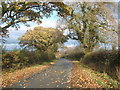
The town of Barnard Castle can be glimpsed on the far side of the River Tees.
Image: © Oliver Dixon
Taken: 18 Jan 2017
0.02 miles
4
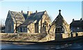
Startforth school
The part blocked archway is inscribed 'Morritt Memorial School' whilst a date of 1877 is carved in the lintel of the blocked doorway to the left. Presumably the benefactors were the Morritts of Rokeby Park.
Image: © Gordon Hatton
Taken: 19 Jan 2022
0.13 miles
5
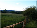
Field and gate
Looking towards Startforth.
Image: © Carol Rose
Taken: 29 Jun 2007
0.20 miles