IMAGES TAKEN NEAR TO
Greenfield, BARNARD CASTLE, DL12 9PX
Introduction
This page details the photographs taken nearby to Greenfield, DL12 9PX by members of the Geograph project.
The Geograph project started in 2005 with the aim of publishing, organising and preserving representative images for every square kilometre of Great Britain, Ireland and the Isle of Man.

There are currently over 7.5m images from over14,400 individuals and you can help contribute to the project by visiting https://www.geograph.org.uk
Image Map
Images are licensed for reuse under creativecommons.org/licenses/by-sa/2.0
Notes
- Clicking on the map will re-center to the selected point.
- The higher the marker number, the further away the image location is from the centre of the postcode.
Image Listing (58 Images Found)
Images are licensed for reuse under creativecommons.org/licenses/by-sa/2.0
Image
Details
Distance
1
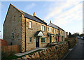
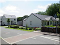
New Houses in Cotherstone
The contractors seemed to be working on these new houses for an inordinate amount of time, with mesh fencing out into the road and generally causing traffic chaos. Fortunately they are now finished and, indeed, lived in. There are two short terraces of four houses each, of which this is the more northerly. The mortar in the garden walls is a little skimpy to make them look more like drystone walls, but the stone is all so new that they look a little out of place. No doubt a few years exposed to the weather will see them blend in a little more, and perhaps develop some individuality as the residents get round to painting their windows and doors different colours.
Image: © Andy Waddington
Taken: 11 Nov 2009
0.02 miles
2
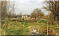
Cotherstone station (remains), 1989
View NW, towards Middleton-in-Teesdale: ex-NER Barnard Castle - Middleton-in-Teesdale line. The station and line closed to passengers on 30/11/64, completely on 5/4/65.
Image: © Ben Brooksbank
Taken: 29 Mar 1989
0.05 miles
3
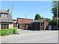
Entrance to W S Hodgson & Co., Cotherstone
W.S. Hodgson & Co. Ltd. is a family run company manufacturing traditional wooden buildings (garden rooms, sheds, stables etc.). The business was founded in 1906 providing poultry houses to local farmers.
http://www.hodgsontimberbuildings.co.uk/
There is a view of their unusual (possibly self-built) factory here: Image
Image: © Andrew Curtis
Taken: 27 Jun 2019
0.05 miles
4
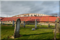
Sheds beside cemetery in Cotherstone
An odd juxtaposition of an industrial building (Hodgson's Quality Timber Buildings) and the tranquility of the village cemetery.
Image: © Trevor Littlewood
Taken: 9 Mar 2014
0.07 miles
5
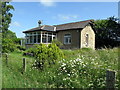
Cotherstone station, Tees Valley Railway
Now a house and garden, which the Tees Railway Path diverts round.
Image: © Christine Johnstone
Taken: 28 Feb 2020
0.07 miles
6
The Station, Low Lathbury, Cotherstone
Formerly Cotherstone Station (opened in 1868) on the Tees Valley Railway between Barnard castle and Middleton in Teesdale. The station was downgraded to an unstaffed halt in 1954 and closed with the line in 1964.
http://www.disused-stations.org.uk/c/cotherstone/
There is a photo here taken in 1989 Image and one in operation here http://cotherstoneparishcouncil.org.uk/history/
Image: © Andrew Curtis
Taken: 28 Jun 2019
0.07 miles
9
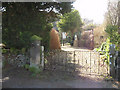
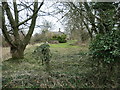
Footpath through private residence in Cotherstone
Image: © Peter Robinson
Taken: 6 Mar 2011
0.11 miles
10
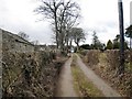
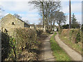
Mire Lane
This photograph shows a view of Mire Lane as it approaches the B6277 minor road in Cotherstone. The picture was taken looking in a westerly direction towards Scalehow Rigg.
Image: © Philip Barker
Taken: 14 Mar 2010
0.11 miles