IMAGES TAKEN NEAR TO
Lartington, BARNARD CASTLE, DL12 9DP
Introduction
This page details the photographs taken nearby to DL12 9DP by members of the Geograph project.
The Geograph project started in 2005 with the aim of publishing, organising and preserving representative images for every square kilometre of Great Britain, Ireland and the Isle of Man.

There are currently over 7.5m images from over14,400 individuals and you can help contribute to the project by visiting https://www.geograph.org.uk
Image Map
Images are licensed for reuse under creativecommons.org/licenses/by-sa/2.0
Notes
- Clicking on the map will re-center to the selected point.
- The higher the marker number, the further away the image location is from the centre of the postcode.
Image Listing (9 Images Found)
Images are licensed for reuse under creativecommons.org/licenses/by-sa/2.0
Image
Details
Distance
1
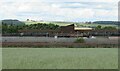
Lartington Water Works
A small section of a very large site. A check to see where water came from for filtration at this site revealed very little information. Logic would suggest that it processes water from the 3 reservoirs in Baldersdale, but the site is mentioned on the Darlington local authority website which says that processing here is for water coming from the Tees.
Image: © Gordon Hatton
Taken: 17 Jul 2023
0.02 miles
2
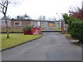
Entrance to Lartington Water Treatment Works
A large facility beside the B6277.
Image: © Oliver Dixon
Taken: 18 Jan 2017
0.09 miles
3
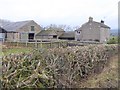
Mense House Farm
A well managed hedgerow in the foreground.
Image: © Oliver Dixon
Taken: 18 Jan 2017
0.11 miles
4

Lartington Waterworks
Realease Valve, next to one of the water tanks & pump house at Lartington Water Treatment Works
Image: © Matthew Hatton
Taken: 12 Jan 2007
0.12 miles
5
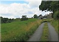
Road to Naby farm
Presumably this is a public road. If the status were less, then the OS map would have the bridleway markings along here.
Image: © Gordon Hatton
Taken: 17 Jul 2023
0.17 miles
6
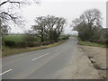
Road (B6277) near Mense House
Looking north-eastward.
Image: © Peter Wood
Taken: 28 Mar 2017
0.18 miles
7
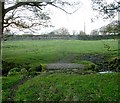
Bridleway crossing Common Sike
This bridleway leaves the B6277 via the galvanised gate and crosses Common Sike by this little bridge before turning east to follow the south bank. At about the point that Common Sike changes name to Grise Beck, the bridleway heads off SE and splits.
Image: © Andy Waddington
Taken: 11 Nov 2009
0.22 miles
8
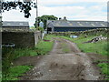
Entering the farmyard at Naby
Along the route of a bridleway that passes through the farm.
Image: © Gordon Hatton
Taken: 17 Jul 2023
0.24 miles
9
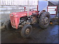
Battered and Bruised
An ancient beast in Naby.
Image: © Matthew Hatton
Taken: 12 Jan 2008
0.24 miles