IMAGES TAKEN NEAR TO
Lartington, BARNARD CASTLE, DL12 9DA
Introduction
This page details the photographs taken nearby to DL12 9DA by members of the Geograph project.
The Geograph project started in 2005 with the aim of publishing, organising and preserving representative images for every square kilometre of Great Britain, Ireland and the Isle of Man.

There are currently over 7.5m images from over14,400 individuals and you can help contribute to the project by visiting https://www.geograph.org.uk
Image Map
Images are licensed for reuse under creativecommons.org/licenses/by-sa/2.0
Notes
- Clicking on the map will re-center to the selected point.
- The higher the marker number, the further away the image location is from the centre of the postcode.
Image Listing (49 Images Found)
Images are licensed for reuse under creativecommons.org/licenses/by-sa/2.0
Image
Details
Distance
2
![A circular walk from Barnard Castle [47]](https://s1.geograph.org.uk/geophotos/07/26/87/7268705_62f7ae57_120x120.jpg)
A circular walk from Barnard Castle [47]
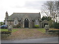
Now a private house, this former Wesleyan Methodist church was built in 1923 and closed in the late 1980s. Constructed of squared, coursed sandstone with ashlar dressings under a slate roof.
After crossing the River Tees, the route follows Deepdale Beck for a short distance before branching northwest to Raygill and Osmond Flatt. Then further west on a bridleway before turning north on a footpath to Lartington. After passing through the village, there is a turn to the north at Lartington Hall, then the route heads southeast past Grotto Wood and Pecknell Wood to the west bank of the river Tees, where it joins the long distance Teesdale Way to return to Barnard Castle. Just under 5½ miles.
Image: © Michael Dibb
Taken: 18 Jun 2022
0.03 miles
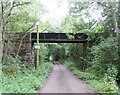
3
![A circular walk from Barnard Castle [46]](https://s3.geograph.org.uk/geophotos/07/26/87/7268703_d9d760f9_120x120.jpg)
A circular walk from Barnard Castle [46]
The parapet of the bridge carrying Lartington Lane over the dismantled railway. The line, known as the Stainmore Line, was built by the South Durham & Lancashire Union Railway, linking the Stockton & Darlington Railway near Bishop Auckland with the Lancaster and Carlisle Railway at Tebay. The line opened in 1861 and closed in stages between 1952 and 1962.
After crossing the River Tees, the route follows Deepdale Beck for a short distance before branching northwest to Raygill and Osmond Flatt. Then further west on a bridleway before turning north on a footpath to Lartington. After passing through the village, there is a turn to the north at Lartington Hall, then the route heads southeast past Grotto Wood and Pecknell Wood to the west bank of the river Tees, where it joins the long distance Teesdale Way to return to Barnard Castle. Just under 5½ miles.
Image: © Michael Dibb
Taken: 18 Jun 2022
0.04 miles
5
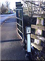
North Eastern Railway Sign
Cast iron sign at the side of the road bridge in Lartington.
Image: © Matthew Hatton
Taken: 12 Jan 2008
0.04 miles
6
![A circular walk from Barnard Castle [45]](https://s1.geograph.org.uk/geophotos/07/26/87/7268701_d44dd71e_120x120.jpg)
A circular walk from Barnard Castle [45]
A large fungus growing near the former railway bridge in Lartington Lane.
After crossing the River Tees, the route follows Deepdale Beck for a short distance before branching northwest to Raygill and Osmond Flatt. Then further west on a bridleway before turning north on a footpath to Lartington. After passing through the village, there is a turn to the north at Lartington Hall, then the route heads southeast past Grotto Wood and Pecknell Wood to the west bank of the river Tees, where it joins the long distance Teesdale Way to return to Barnard Castle. Just under 5½ miles.
Image: © Michael Dibb
Taken: 18 Jun 2022
0.05 miles
7
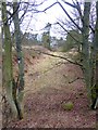
Trackbed of old railway at Lartington
The railway from Barnard Castle to Middleton-in-Teesdale closed in 1965. The house in the distance was probably the old station.
Image: © Oliver Dixon
Taken: 18 Jan 2017
0.05 miles
8
'The sheep now arriving at platform one...'
The former station at Lartington, once served by trains travelling between Barnard castle and Tebay. Sheep now graze where the lines once ran.
Image: © Gordon Hatton
Taken: 12 Jan 2008
0.08 miles
9
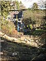
Scene of a fatal accident
This is an aqueduct carrying a small beck over the route of the former railway line at Lartington. On December 8th 1873, George Pearson, the driver of a mineral goods train was, for some strange reason, standing either on his engine or the tender and was knocked off as the train went under the bridge. The 17 laden wagons and guards van then ran over his body, decapitating him and cutting his body in two.
Image: © Gordon Hatton
Taken: 17 Jul 2023
0.08 miles
10
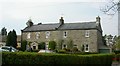
![A circular walk from Barnard Castle [44]](https://s0.geograph.org.uk/geophotos/07/26/87/7268700_c2df3896_120x120.jpg)
A circular walk from Barnard Castle [44]
Now a private house, The Woodlands is the former Lartington railway station. The property comprises the station master's house, waiting room and ticket office, dated 1859. Constructed, in a Tudor style, for the South Durham and Lancashire Union Railway Company. Built of dressed sandstone with ashlar dressings, the waiting room is weatherboarded, all the roofs are of Welsh slate. Listed, grade II, with details at: https://historicengland.org.uk/listing/the-list/list-entry/1121026
After crossing the River Tees, the route follows Deepdale Beck for a short distance before branching northwest to Raygill and Osmond Flatt. Then further west on a bridleway before turning north on a footpath to Lartington. After passing through the village, there is a turn to the north at Lartington Hall, then the route heads southeast past Grotto Wood and Pecknell Wood to the west bank of the river Tees, where it joins the long distance Teesdale Way to return to Barnard Castle. Just under 5½ miles.
Image: © Michael Dibb
Taken: 18 Jun 2022
0.08 miles