IMAGES TAKEN NEAR TO
Bowes Way, BARNARD CASTLE, DL12 9AJ
Introduction
This page details the photographs taken nearby to Bowes Way, DL12 9AJ by members of the Geograph project.
The Geograph project started in 2005 with the aim of publishing, organising and preserving representative images for every square kilometre of Great Britain, Ireland and the Isle of Man.

There are currently over 7.5m images from over14,400 individuals and you can help contribute to the project by visiting https://www.geograph.org.uk
Image Map
Images are licensed for reuse under creativecommons.org/licenses/by-sa/2.0
Notes
- Clicking on the map will re-center to the selected point.
- The higher the marker number, the further away the image location is from the centre of the postcode.
Image Listing (252 Images Found)
Images are licensed for reuse under creativecommons.org/licenses/by-sa/2.0
Image
Details
Distance
1
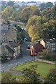
Bowes Road, Startforth
Viewed from the castle a small side road cuts the corner to the A67 Bowes Road (for pedestrians). In the distance is the Deerbolt Young Offenders Institute.
Image: © Mick Garratt
Taken: 21 Oct 2007
0.05 miles
2
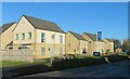
New development, Startforth
New housing development off Bowes Road in Startforth.
Image: © Gordon Hatton
Taken: 19 Jan 2022
0.07 miles
3
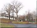
Grounds of Deerbolt Young Offender Institute
View from roadside of the entrance to Her Majesty's Young Offender Institute, Deerbolt. It was formerly an army camp.
Image: © David Hawgood
Taken: 10 Jan 2009
0.08 miles
5
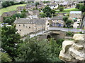
Barnard Castle
The bridge over the Tees seen from the curtain wall of Barnard Castle.
Image: © Nick Wright
Taken: 3 Sep 2009
0.10 miles
6
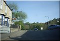
Traffic lights in Startforth
Where the B6277 crosses the A67, opposite Barnard Castle.
Image: © Stanley Howe
Taken: 30 Apr 2011
0.11 miles
7
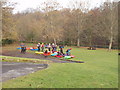
Kayakers prepare to embark on the Tees
The kayakers received a briefing on this picnic area and got ready - then embarked, see Image
Image: © David Hawgood
Taken: 10 Jan 2009
0.12 miles
8
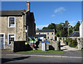
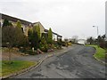
Houses in Startforth
Startforth being on the west side of the River Tees was once in Yorkshire whereas Barnard Castle on the east side of the river was in County Durham. By the Local Government Act of 1972 Startforth was absorbed with other parts of Yorkshire into County Durham. The view is from the County Bridge over the Tees. The blue and yellow sign is a feature of place names in County Durham though not all are in that style.
Image: © Trevor Littlewood
Taken: 31 Aug 2014
0.12 miles
9
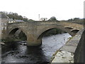
Barnard Castle County Bridge
The bridge carries the A67 (Bridgegate) across the river Tees just below the castle.
Image: © G Laird
Taken: 3 Apr 2017
0.13 miles
10
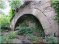
Old culvert?
To be found on the west bank of the River Tees50m upstream of Barnard Castle Bridge
Image: © Alexander P Kapp
Taken: 24 Jun 2011
0.13 miles