IMAGES TAKEN NEAR TO
High Startforth, BARNARD CASTLE, DL12 9AF
Introduction
This page details the photographs taken nearby to DL12 9AF by members of the Geograph project.
The Geograph project started in 2005 with the aim of publishing, organising and preserving representative images for every square kilometre of Great Britain, Ireland and the Isle of Man.

There are currently over 7.5m images from over14,400 individuals and you can help contribute to the project by visiting https://www.geograph.org.uk
Image Map
Images are licensed for reuse under creativecommons.org/licenses/by-sa/2.0
Notes
- Clicking on the map will re-center to the selected point.
- The higher the marker number, the further away the image location is from the centre of the postcode.
Image Listing (63 Images Found)
Images are licensed for reuse under creativecommons.org/licenses/by-sa/2.0
Image
Details
Distance
1
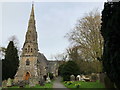
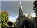
Holy Trinity Church, Startforth
Grade II listed church from 1867. Details from Historic England here: https://historicengland.org.uk/listing/the-list/list-entry/1310294
Image: © David Robinson
Taken: 27 Apr 2018
0.07 miles
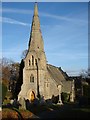
3
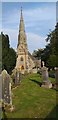
Holy Trinity Church, Startforth
Holy Trinity church sits on the southern edge of Startforth on the western side of the B6277 as it leaves the village. The church is a Victorian rebuild which was completed in 1863. The style used is Early English although Pevsner devotes only a few lines to it. There was clearly nothing significant architecturally in the building although its spire is a rather handsome addition to the skyline. The church sits behind a mid-height stone wall and access is through an attractive lychgate. There are a few trees in the graveyard which rather restrict viewing.
Image: © Colin Kinnear
Taken: 15 Sep 2020
0.09 miles
4
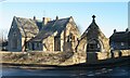
Startforth school
The part blocked archway is inscribed 'Morritt Memorial School' whilst a date of 1877 is carved in the lintel of the blocked doorway to the left. Presumably the benefactors were the Morritts of Rokeby Park.
Image: © Gordon Hatton
Taken: 19 Jan 2022
0.09 miles

7
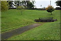
Church Bank Field
A micropark in Startforth
Image: © Bob Harvey
Taken: 21 Sep 2017
0.12 miles
8
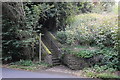
The start of a path
Footsteps as part of a public path
Image: © Bob Harvey
Taken: 21 Sep 2017
0.12 miles
9

A thing of the past?
Signs like this will soon be a historic curiosity.
on the gate at Image
Image: © Bob Harvey
Taken: 21 Sep 2017
0.12 miles
10
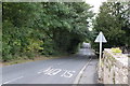
The Sills
Road embanked above the River Tees. It once offered a fine view of the river, on the right, but is now heavily obscured by trees.
Image: © Bob Harvey
Taken: 21 Sep 2017
0.13 miles