IMAGES TAKEN NEAR TO
Westwick, BARNARD CASTLE, DL12 8UT
Introduction
This page details the photographs taken nearby to DL12 8UT by members of the Geograph project.
The Geograph project started in 2005 with the aim of publishing, organising and preserving representative images for every square kilometre of Great Britain, Ireland and the Isle of Man.

There are currently over 7.5m images from over14,400 individuals and you can help contribute to the project by visiting https://www.geograph.org.uk
Image Map
Images are licensed for reuse under creativecommons.org/licenses/by-sa/2.0
Notes
- Clicking on the map will re-center to the selected point.
- The higher the marker number, the further away the image location is from the centre of the postcode.
Image Listing (2 Images Found)
Images are licensed for reuse under creativecommons.org/licenses/by-sa/2.0
Image
Details
Distance
1
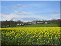
West Shaws
On a hill above a field of oilseed rape.
Image: © Jonathan Thacker
Taken: 4 May 2018
0.02 miles
2
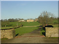
West Shaws near Barnard Castle
West Shaws on the Whorlton to Barnard Castle road
Image: © Oliver Dixon
Taken: 12 Dec 2005
0.08 miles