IMAGES TAKEN NEAR TO
Darlington Road, BARNARD CASTLE, DL12 8TA
Introduction
This page details the photographs taken nearby to Darlington Road, DL12 8TA by members of the Geograph project.
The Geograph project started in 2005 with the aim of publishing, organising and preserving representative images for every square kilometre of Great Britain, Ireland and the Isle of Man.

There are currently over 7.5m images from over14,400 individuals and you can help contribute to the project by visiting https://www.geograph.org.uk
Image Map
Images are licensed for reuse under creativecommons.org/licenses/by-sa/2.0
Notes
- Clicking on the map will re-center to the selected point.
- The higher the marker number, the further away the image location is from the centre of the postcode.
Image Listing (7 Images Found)
Images are licensed for reuse under creativecommons.org/licenses/by-sa/2.0
Image
Details
Distance
1
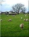
Sheep graze south of Sunningdale Farm
The sheep are in a field just off the byway from Green Lane to the Mount Eff road, whilst the farm is the other side of the A67 Darlington Road.
Image: © Andy Waddington
Taken: 5 Dec 2009
0.01 miles
2
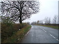
Darlington Road (A67)
Heading west towards Barnard Castle.
Image: © JThomas
Taken: 7 Nov 2015
0.11 miles
3
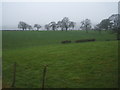
Grazing east of Barnard Castle
Fields off Darlington Road (A67)
Image: © JThomas
Taken: 7 Nov 2015
0.12 miles
5
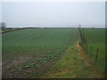
Crop field and hedgerow
South of Darlington Road (A67).
Image: © JThomas
Taken: 7 Nov 2015
0.17 miles
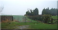
6
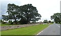
Approaching the entrance to Jersey Farm Hotel
Image: © Anthony Parkes
Taken: 28 Jun 2014
0.18 miles
7
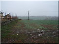
Crop field on the outskirts of Barnard Castle
Looking south from the A67.
New housing is being built to the left
See Image
Image: © JThomas
Taken: 7 Nov 2015
0.25 miles