IMAGES TAKEN NEAR TO
Marwood, BARNARD CASTLE, DL12 8RL
Introduction
This page details the photographs taken nearby to DL12 8RL by members of the Geograph project.
The Geograph project started in 2005 with the aim of publishing, organising and preserving representative images for every square kilometre of Great Britain, Ireland and the Isle of Man.

There are currently over 7.5m images from over14,400 individuals and you can help contribute to the project by visiting https://www.geograph.org.uk
Image Map
Images are licensed for reuse under creativecommons.org/licenses/by-sa/2.0
Notes
- Clicking on the map will re-center to the selected point.
- The higher the marker number, the further away the image location is from the centre of the postcode.
Image Listing (44 Images Found)
Images are licensed for reuse under creativecommons.org/licenses/by-sa/2.0
Image
Details
Distance
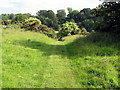
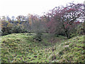
2
Ditch and rampart at the Iron Age settlement by Balder Foot
Image: © Mike Quinn
Taken: 10 Nov 2018
0.13 miles
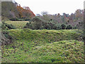
4
Ditch and rampart at the Iron Age settlement by Balder Foot (2)
Image: © Mike Quinn
Taken: 10 Nov 2018
0.14 miles
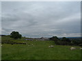
6
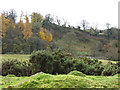
Iron Age settlement by Balder Foot
Looking across the valley of the River Tees towards Image
Image: © Mike Quinn
Taken: 10 Nov 2018
0.15 miles
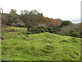
7
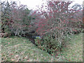
Gap in the earthwork at the Iron Age settlement by Balder Foot
Image: © Mike Quinn
Taken: 10 Nov 2018
0.15 miles
8
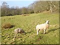
Sheep in Teesdale
A short way above the Cotherstone footbridge.
Image: © Oliver Dixon
Taken: 6 Feb 2017
0.16 miles
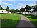
9
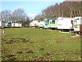
Caravan site at Lower Shipley Farm
Hidden in the trees above the Tees gorge.
Image: © Oliver Dixon
Taken: 6 Feb 2017
0.16 miles