IMAGES TAKEN NEAR TO
Marwood, BARNARD CASTLE, DL12 8RG
Introduction
This page details the photographs taken nearby to DL12 8RG by members of the Geograph project.
The Geograph project started in 2005 with the aim of publishing, organising and preserving representative images for every square kilometre of Great Britain, Ireland and the Isle of Man.

There are currently over 7.5m images from over14,400 individuals and you can help contribute to the project by visiting https://www.geograph.org.uk
Image Map
Images are licensed for reuse under creativecommons.org/licenses/by-sa/2.0
Notes
- Clicking on the map will re-center to the selected point.
- The higher the marker number, the further away the image location is from the centre of the postcode.
Image Listing (9 Images Found)
Images are licensed for reuse under creativecommons.org/licenses/by-sa/2.0
Image
Details
Distance
1
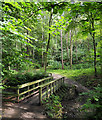
Woodland glade beyond footbridge
The woods line the sides of the minor stream, Percy Beck, which is a tributary to the River Tees running in a steep-sided valley on the west side of Barnard Castle.
Image: © Trevor Littlewood
Taken: 30 Jul 2017
0.12 miles
2
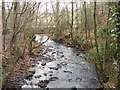
Percy Beck, Barnard Castle
Stream through Flatts Woods.
Image: © David Hawgood
Taken: 10 Jan 2009
0.14 miles
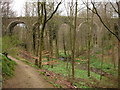
3

Path through Flatts Wood
One of the bridges that takes the path over Percy Beck.
Image: © Gordon Hatton
Taken: 19 Jan 2022
0.15 miles
4
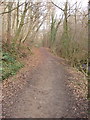
Path in Flatts Woods, Barnard Castle
Percy Beck is on the right. The woods are owned by the Vane family of Raby Castle. Paths through the woods for the use of the public started to be laid out by local residents 200 years ago.
Image: © David Hawgood
Taken: 10 Jan 2009
0.16 miles
5
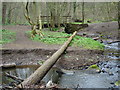
Alternative crossing
Judging by the worn path and the degree of polish on top of this fallen tree, I was by no means the first to use it as an alternative means of crossing Percy Beck. Between the log and the bridge, Black Beck comes in from the right of the view, but this is a minor tributary, so it is easy to step over that to return to the path.
Image: © Andy Waddington
Taken: 17 Apr 2009
0.21 miles
6

Percy Beck
Looking upstream from one of the footbridges spanning the beck.
Image: © Gordon Hatton
Taken: 19 Jan 2022
0.22 miles
7
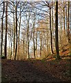
Winter sunshine, Flatts Wood
Sunlight filters through beech trees in Flatts Wood.
Image: © Gordon Hatton
Taken: 19 Jan 2022
0.23 miles
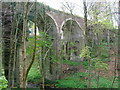
9
Percy Beck viaduct
This bridge was built by the South Durham and Lancashire Railway and was completed in 1861, carrying traffic from Barnard Castle across the Pennines to the main line in the west. The line had many spectacular trestle viaducts, all now removed, but this stone-built one with brick arches remains, now carrying a private road, having been closed as a railway in 1964. Flatts Wood, through which this view was taken, is a popular walking and children's play spot, being on the fringes on Barnard Castle, with footpaths down to the River Tees.
Image: © Andy Waddington
Taken: 17 Apr 2009
0.25 miles