IMAGES TAKEN NEAR TO
Old School Close, BARNARD CASTLE, DL12 8PS
Introduction
This page details the photographs taken nearby to Old School Close, DL12 8PS by members of the Geograph project.
The Geograph project started in 2005 with the aim of publishing, organising and preserving representative images for every square kilometre of Great Britain, Ireland and the Isle of Man.

There are currently over 7.5m images from over14,400 individuals and you can help contribute to the project by visiting https://www.geograph.org.uk
Image Map
Images are licensed for reuse under creativecommons.org/licenses/by-sa/2.0
Notes
- Clicking on the map will re-center to the selected point.
- The higher the marker number, the further away the image location is from the centre of the postcode.
Image Listing (343 Images Found)
Images are licensed for reuse under creativecommons.org/licenses/by-sa/2.0
Image
Details
Distance
1
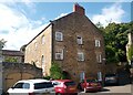
Former Broadgates Methodist Chapel, West View, Barnard Castle
Grade II Listed former Methodist Chapel dated 1764 on the west gable - this is the east gable. The blue plaque states that "This building, originally known as Broadgates Chapel, was the first Methodist Chapel to be built in Barnard Castle. Much of the labour in erecting it was undertaken by the men and women of the congregation. John Wesley preached in the opening service." There is more on the plaque but it is difficult to make out from the photograph on the Historic England website. https://historicengland.org.uk/listing/the-list/list-entry/1282876. The sign over the arch says Broadgates, which is a walkway leading across to the Bank. The building is now apartments.
Image: © Stephen Armstrong
Taken: 3 Aug 2024
0.05 miles
2
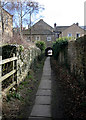
Broadgates
This tiny ginnel, entered off The Bank at NZ05011622 is called Broadgates and leads under an arched tunnel below the house seen here. There are a whole series of parallel little paths, much used by locals, but not shown on any street maps I've seen, so they are pleasantly free from tourists.
Image: © Andy Waddington
Taken: 5 Mar 2009
0.06 miles
3

Path down to the river
A narrow alleyway runs from Queen Street (Hole in the Wall) down to the river. This section is just below Newgate.
Image: © Oliver Dixon
Taken: 21 Sep 2016
0.07 miles
4
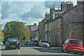
Barnard Castle : Newgate
Looking along Newgate.
Image: © Lewis Clarke
Taken: 25 Sep 2020
0.07 miles
5

Newgate in Barnard Castle
Looking south-eastward.
Image: © Peter Wood
Taken: 28 Mar 2017
0.07 miles
6

St Mary's Parish Church, Barnard Castle. Graveyard
Image: © Alexander P Kapp
Taken: 24 Jun 2011
0.08 miles
7

East Window, St Mary's Parish Church, Barnard Castle
Image: © David Dixon
Taken: 24 Jun 2011
0.08 miles
8

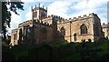
St Mary's Parish Church, Barnard Castle
St Mary's Church, founded in the 12th century, includes many later additions.
Image: © David Dixon
Taken: 24 Jun 2011
0.08 miles

10
St. Mary's Parish Church, Barnard Castle
Grade I Listed C12 Parish Church, viewed from the south. https://historicengland.org.uk/listing/the-list/list-entry/1218277
Image: © Stephen Armstrong
Taken: 3 Aug 2024
0.09 miles