IMAGES TAKEN NEAR TO
Watson Court, BARNARD CASTLE, DL12 8LT
Introduction
This page details the photographs taken nearby to Watson Court, DL12 8LT by members of the Geograph project.
The Geograph project started in 2005 with the aim of publishing, organising and preserving representative images for every square kilometre of Great Britain, Ireland and the Isle of Man.

There are currently over 7.5m images from over14,400 individuals and you can help contribute to the project by visiting https://www.geograph.org.uk
Image Map
Images are licensed for reuse under creativecommons.org/licenses/by-sa/2.0
Notes
- Clicking on the map will re-center to the selected point.
- The higher the marker number, the further away the image location is from the centre of the postcode.
Image Listing (499 Images Found)
Images are licensed for reuse under creativecommons.org/licenses/by-sa/2.0
Image
Details
Distance
1
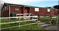
Barnard Castle Guide Hut
Unlike the Scouts, Barney Guides really do have a hut !
Image: © Andy Waddington
Taken: 5 Mar 2009
0.02 miles
2
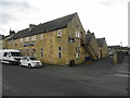
Barnard Castle Rugby Club - Birch Street
Former Great War era Drill Hall built to a design by architect George Richardson Smith, South Shields for the Durham County Territorial Association. The drawings are dated 1911-1914 so not clear if built by outbreak of war but shown on mapping dated 1921. Territorial Associations took over responsibility for provision of facilities in 1908 and many old Rifle Volunteer and Militia halls were no longer considered suitable.
Image: © John M
Taken: 18 Jul 2018
0.05 miles
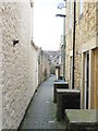
3
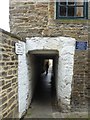
Hole in the wall
The start of an alleyway running from Queen Street down to the river. The blue plaque commemorates that the building was at one time a meeting house where John Wesley, the founder of Methodism, preached.
Image: © Oliver Dixon
Taken: 21 Sep 2016
0.06 miles
4

Chapel Court Drug Culture
This plaque is on the building it describes, facing into the narrow ginnel leading from "Hole in the Wall" to Newgate. It's a sheltered spot out of sight of passing law enforcement and seems to be the place to go to smoke your joint, judging by the graffiti ! The same graffiti was on the patch repainted at top left ...
Image: © Andy Waddington
Taken: 5 Mar 2009
0.09 miles
6
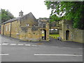
Gate to Militia Barracks
In 1853 the Durham Militia raised in 1759 by the Earl of Darlington was split into North and South Battalions with the South here in Barnard Castle. With reforms in 1881 this became the 4th Battalion Durham Light Infantry. Changes in 1908 changed this to a reserve battalion. Manned by former regulars the Battalion saw service in the Boer War and Home Service in the Great War. The barracks closed in 1930.
Image: © John M
Taken: 18 Jul 2018
0.10 miles
7
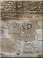
Old Boundary Marker in Barnard Castle
Estate Boundary Marker - War Department #1 by Wilson Street, in parish of Barnard Castle (Teesdale District). Junction of Wilson Street and Birch Road, set in stone wall.
Surveyed
Milestone Society National ID: DU_WDBARC01em.
Image: © Milestone Society
Taken: Unknown
0.10 miles
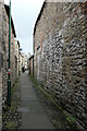
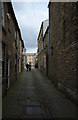
9
Waterloo Yard
A narrow alleyway off the marketplace in Barnard Castle. A little further south in Yorkshire this would be known as a ginnel, or if in York, a snickleway.
Image: © Gordon Hatton
Taken: 11 Jul 2020
0.10 miles
10
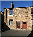
West end of terrace, Ware Street
The end house of the terrace on the north side of Ware Street gets more sun than any other house in the road, since the house faces down the length of George Street which runs almost due south. Compare this with Image] taken less than a minute later - the darkness there makes the blue sky seen here look totally white, whereas the sun on the south-facing stone makes the sky look almost Mediterranean, and somewhat in contrast to the feel of the day, with a bitterly cold wind.
Image: © Andy Waddington
Taken: 30 Jan 2010
0.10 miles