IMAGES TAKEN NEAR TO
Nickleby Close, BARNARD CASTLE, DL12 8HZ
Introduction
This page details the photographs taken nearby to Nickleby Close, DL12 8HZ by members of the Geograph project.
The Geograph project started in 2005 with the aim of publishing, organising and preserving representative images for every square kilometre of Great Britain, Ireland and the Isle of Man.

There are currently over 7.5m images from over14,400 individuals and you can help contribute to the project by visiting https://www.geograph.org.uk
Image Map
Images are licensed for reuse under creativecommons.org/licenses/by-sa/2.0
Notes
- Clicking on the map will re-center to the selected point.
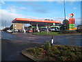
- The higher the marker number, the further away the image location is from the centre of the postcode.
Image Listing (17 Images Found)
Images are licensed for reuse under creativecommons.org/licenses/by-sa/2.0
Image
Details
Distance
2
Teesdale School
A Comprehensive school for 11 to 18 year olds.
Image: © Mick Garratt
Taken: 21 Oct 2007
0.07 miles
4

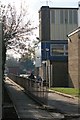
Teesdale Sports Centre, main entrance
The main sports facility for Barnard Castle residents not wanting to do free, outdoor adventure sports, but still keep fit. As well as a swimming pool, and halls/courts for various sports involving hitting or kicking flying objects, there are gymnasia and all the usual stuff. Fortunately, enlightenment has recently arrived, and there is now an indoor climbing wall, giving us an excuse to visit, and also to keep fit when the weather is truly awful.
Image: © Andy Waddington
Taken: 28 Feb 2010
0.11 miles
7
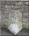
Old Milestone by the A688, Bede Road, Barnard Castle
Carved stone post by the A688, in parish of Barnard Castle (Teesdale District), Bede Road, East of junction with Victoria Road, junction with A67, set against wall, on South side of road. Bowes stone, erected by the Bowes & Sunderland Bridge Turnpike Trust in the 19th century.
Inscription reads:-
: BOWES / 5 : : DURHAM / 24 :
Grade II Listed. List Entry Number: 1282873
https://historicengland.org.uk/listing/the-list/list-entry/1282873
Milestone Society National ID: DU_DUBO24.
Image: © Milestone Society
Taken: 9 Oct 2017
0.16 miles
8
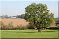
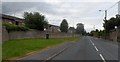
School Playing Fields
Belonging to Teesdale School. Beyond lies the village of Stainton.
Image: © Mick Garratt
Taken: 21 Oct 2007
0.17 miles
9
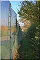
Public Footpath to Stainton
Running alongside the rather intimidating security fence surrounding the GlaxoSmithKline works.
Image: © Mick Garratt
Taken: 21 Oct 2007
0.18 miles
10
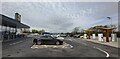
New Lidl Supermarket East of Barnard Castle
Image: © Anthony Parkes
Taken: 22 Apr 2022
0.18 miles