IMAGES TAKEN NEAR TO
Railway Terrace, BARNARD CASTLE, DL12 8DU
Introduction
This page details the photographs taken nearby to Railway Terrace, DL12 8DU by members of the Geograph project.
The Geograph project started in 2005 with the aim of publishing, organising and preserving representative images for every square kilometre of Great Britain, Ireland and the Isle of Man.

There are currently over 7.5m images from over14,400 individuals and you can help contribute to the project by visiting https://www.geograph.org.uk
Image Map
Images are licensed for reuse under creativecommons.org/licenses/by-sa/2.0
Notes
- Clicking on the map will re-center to the selected point.
- The higher the marker number, the further away the image location is from the centre of the postcode.
Image Listing (15 Images Found)
Images are licensed for reuse under creativecommons.org/licenses/by-sa/2.0
Image
Details
Distance
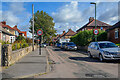
1
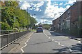
Barnard Castle : Harmire Road B6278
Looking along Harmire Road.
Image: © Lewis Clarke
Taken: 25 Sep 2020
0.04 miles
2
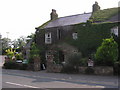
Red Well Inn
On the B6278 Barnard Castle to Eggleston
Image: © Hugh Mortimer
Taken: 20 Jul 2006
0.10 miles
3
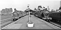
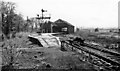
Barnard Castle station, with trains 1953
View east on the island platform, with two trains: on the left, Worsdell NER J21 0-6-0 No. 65068 (built 12/1890 as No. 300, 1946 LNER No. 5068, withdrawn 6/54) on a Darlington - Kirby Stephen - Penrith train; on the right is NER A8 4-6-2T No. 69851 (built 10/1913 as No. 2144, withdrawn 11/58) on a Sunderland - Middleton-in-Teesdale train. Barnard Castle station was closed 30/11/64 (passengers), 6/4/65 to goods, following closure of the Middleton line; the Darlington - Penrith line over Stainmore closed 20/1/62 and that from Bishop Auckland from 20/6/62.
Image: © Walter Dendy, deceased
Taken: 12 Aug 1953
0.10 miles
4
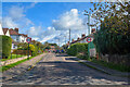
Barnard Castle : Woodlands Road
Looking along Woodlands Road off Harmire Road.
Image: © Lewis Clarke
Taken: 25 Sep 2020
0.10 miles
5
Barnard Castle Station (remains)
View westward of recently closed quite important junction station, where lines from Darlington (closed 30/11/64, Goods 5/4/65) and Bishop Auckland (closed 13/6/62) converged, continuing over Stainmore to Kirkby Stephen and Penrith (closed 22/1/62), also Tebay (until 1/12/52), and from Barnard Castle to Middleton-in-Teesdale (closed 30/11/64, Goods 5/4/65). Here, in May 1965, they are already dismantling everything.
Image: © Ben Brooksbank
Taken: 8 May 1965
0.10 miles
6
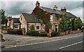
Red Well Inn
The Red Well Inn at Barnard Castle.
Image: © Peter McDermott
Taken: 2 Sep 2011
0.11 miles
7
Barnard Castle : Road
A road and pavement.
Image: © Lewis Clarke
Taken: 25 Sep 2020
0.13 miles
8
Barnard Castle : Cleveland Road
Cleveland Road off Harmire Road.
Image: © Lewis Clarke
Taken: 25 Sep 2020
0.14 miles
9
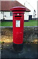
George V postbox on the B6278, Barnard Castle
Postbox No. DL12 93.
Image: © JThomas
Taken: 10 Oct 2021
0.19 miles
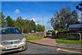
10
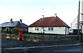
Bungalows on the B6278, Barnard Castle
Showing position of Postbox No. DL12 93.
Image: © JThomas
Taken: 10 Oct 2021
0.20 miles