IMAGES TAKEN NEAR TO
Harmire Enterprise Park, BARNARD CASTLE, DL12 8AX
Introduction
This page details the photographs taken nearby to Harmire Enterprise Park, DL12 8AX by members of the Geograph project.
The Geograph project started in 2005 with the aim of publishing, organising and preserving representative images for every square kilometre of Great Britain, Ireland and the Isle of Man.

There are currently over 7.5m images from over14,400 individuals and you can help contribute to the project by visiting https://www.geograph.org.uk
Image Map
Images are licensed for reuse under creativecommons.org/licenses/by-sa/2.0
Notes
- Clicking on the map will re-center to the selected point.
- The higher the marker number, the further away the image location is from the centre of the postcode.
Image Listing (18 Images Found)
Images are licensed for reuse under creativecommons.org/licenses/by-sa/2.0
Image
Details
Distance
1

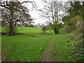
Lawn at premises on Harmire Enterprise Park
The Harmire Enterprise Park is a small scale development at the northern end of Barnard Castle.
Image: © Trevor Littlewood
Taken: 30 Jul 2017
0.07 miles
4
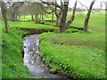
Skirting the golf course
The footpath runs alongside Percy Beck as it flows through Barnard Castle Golf Course. A sign warns walkers not of the competent golfers on the course itself, but of the ones practising off the edge of the course to the right - presumably these are the ones that can't be trusted to hit a ball within ninety degrees of where they intended.
Image: © Andy Waddington
Taken: 17 Apr 2009
0.14 miles
5
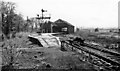
Barnard Castle Station (remains)
View westward of recently closed quite important junction station, where lines from Darlington (closed 30/11/64, Goods 5/4/65) and Bishop Auckland (closed 13/6/62) converged, continuing over Stainmore to Kirkby Stephen and Penrith (closed 22/1/62), also Tebay (until 1/12/52), and from Barnard Castle to Middleton-in-Teesdale (closed 30/11/64, Goods 5/4/65). Here, in May 1965, they are already dismantling everything.
Image: © Ben Brooksbank
Taken: 8 May 1965
0.15 miles
6
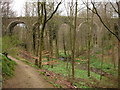
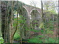
Percy Beck viaduct
This bridge was built by the South Durham and Lancashire Railway and was completed in 1861, carrying traffic from Barnard Castle across the Pennines to the main line in the west. The line had many spectacular trestle viaducts, all now removed, but this stone-built one with brick arches remains, now carrying a private road, having been closed as a railway in 1964. Flatts Wood, through which this view was taken, is a popular walking and children's play spot, being on the fringes on Barnard Castle, with footpaths down to the River Tees.
Image: © Andy Waddington
Taken: 17 Apr 2009
0.15 miles
7
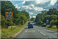
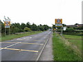
Barnard Castle : B6278
Heading into Barnard Castle.
Image: © Lewis Clarke
Taken: 25 Sep 2020
0.15 miles
8
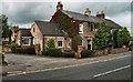
Red Well Inn
The Red Well Inn at Barnard Castle.
Image: © Peter McDermott
Taken: 2 Sep 2011
0.15 miles