IMAGES TAKEN NEAR TO
Flatts Road, BARNARD CASTLE, DL12 8AH
Introduction
This page details the photographs taken nearby to Flatts Road, DL12 8AH by members of the Geograph project.
The Geograph project started in 2005 with the aim of publishing, organising and preserving representative images for every square kilometre of Great Britain, Ireland and the Isle of Man.

There are currently over 7.5m images from over14,400 individuals and you can help contribute to the project by visiting https://www.geograph.org.uk
Image Map
Images are licensed for reuse under creativecommons.org/licenses/by-sa/2.0
Notes
- Clicking on the map will re-center to the selected point.
- The higher the marker number, the further away the image location is from the centre of the postcode.
Image Listing (473 Images Found)
Images are licensed for reuse under creativecommons.org/licenses/by-sa/2.0
Image
Details
Distance
1
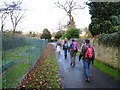
Walkers on the Teesdale Way at Barnard Castle
This photograph shows a group of walkers leaving Barnard Castle as they make their way in a north-westerly direction along the Teesdale Way towards Cotherstone.
Image: © Philip Barker
Taken: 22 Nov 2009
0.02 miles
2
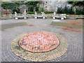
Public art at the Roman Way Picnic Site
This public space was developed on the site of the old Barnard Castle gasworks which were finally demolished in the 1990s. The area is next to the site of the conjectured Roman bridge over the River Tees. The design of the mosaic is based on ideas by primary school children in Bowes; the seats were carved by local sculptor Keith Alexander.
Image: © Oliver Dixon
Taken: 6 Feb 2017
0.04 miles
3
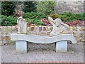
Stone bench at Roman Way Picnic Site (2)
This public space was developed on the site of the old Barnard Castle gasworks which were finally demolished in the 1990s. The area is next to the site of the conjectured Roman bridge over the River Tees. Three stone benches were carved by local sculptor Keith Alexander.
Image: © Oliver Dixon
Taken: 6 Feb 2017
0.04 miles
4
Stone bench at Roman Way Picnic Site (3)
This public space was developed on the site of the old Barnard Castle gasworks which were finally demolished in the 1990s. The area is next to the site of the conjectured Roman bridge over the River Tees. Three stone benches were carved by local sculptor Keith Alexander.
Image: © Oliver Dixon
Taken: 6 Feb 2017
0.04 miles
5
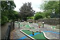
Crazy golf course in Barnard Castle
A 9 hole course near to the castle.
Image: © DS Pugh
Taken: 24 Aug 2022
0.04 miles
6
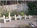
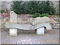
Stone carved seats, Barnard Castle
The seats represent aspects of the River Tees, and of the Roman history of the area. They were carved by Keith Alexander.
Image: © David Hawgood
Taken: 10 Jan 2009
0.04 miles
7
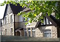
Abbeyfield, Barnard Castle
In Flatts Road.
Image: © Stanley Howe
Taken: 30 Apr 2011
0.04 miles
8
Stone bench at Roman Way Picnic Site (1)
This public space was developed on the site of the old Barnard Castle gasworks which were finally demolished in the 1990s. The area is next to the site of the conjectured Roman bridge over the River Tees. Three stone benches were carved by local sculptor Keith Alexander.
Image: © Oliver Dixon
Taken: 6 Feb 2017
0.04 miles
9
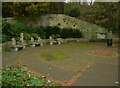
The picnic area near the weir, Barnard Castle
This is on the site of a gas works, of which only the curved retaining wall survives. A Roman road passed through the site.
Image: © Humphrey Bolton
Taken: 6 Nov 2022
0.05 miles
10
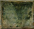
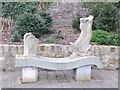
Stone commemorating the discovery of a Roman road, Barnard Castle
This is in the wall of a building. Unfortunately it is difficult to read all of the inscription but the date is 1839, see https://brigantesnation.com/barnard-castle-roman-ford-county-durham , which gives information about the Roman ford across the river.
Image: © Humphrey Bolton
Taken: 6 Nov 2022
0.05 miles