IMAGES TAKEN NEAR TO
Stanhope Road, BARNARD CASTLE, DL12 0RR
Introduction
This page details the photographs taken nearby to Stanhope Road, DL12 0RR by members of the Geograph project.
The Geograph project started in 2005 with the aim of publishing, organising and preserving representative images for every square kilometre of Great Britain, Ireland and the Isle of Man.

There are currently over 7.5m images from over14,400 individuals and you can help contribute to the project by visiting https://www.geograph.org.uk
Image Map
Images are licensed for reuse under creativecommons.org/licenses/by-sa/2.0
Notes
- Clicking on the map will re-center to the selected point.
- The higher the marker number, the further away the image location is from the centre of the postcode.
Image Listing (20 Images Found)
Images are licensed for reuse under creativecommons.org/licenses/by-sa/2.0
Image
Details
Distance
1
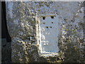
Ordnance Survey Flush Bracket 2269
This bracket can be found on the wall of one of the buildings at High Dyke Farm. The benchmark height is recorded as being 298.83 metres above sea level.
For more detail see : http://www.bench-marks.org.uk/bm10138
Image: © Peter Wood
Taken: 26 Mar 2017
0.04 miles
3
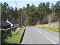
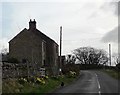
Road at High Dyke Farm
Looking westward.
Image: © Peter Wood
Taken: 26 Mar 2017
0.06 miles
4
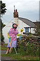
Scarecrow
Scarecrow out on the roadside for the annual competition associated with Middleton Show.
Image: © Helen Wilkinson
Taken: 23 Jul 2007
0.06 miles
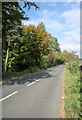
5
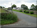
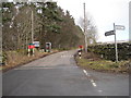
Road to Stanhope from Snaisgill Road
Image: © Peter Robinson
Taken: 10 Jul 2011
0.07 miles
6
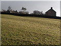
Field on east side of Hudeshope
The field rises steeply from a minor road close to a road junction, north of Middleton-in-Teesdale
Image: © Trevor Littlewood
Taken: 15 Dec 2011
0.08 miles
7
Middleton-in-Teesdale
Road leading out of Middleton-in-Teesdale towards High Dyke.
Image: © Peter McDermott
Taken: 20 Oct 2007
0.09 miles
8
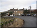
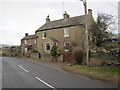
Terraced Houses above Middleton in Teesdale.
Image: © Les Hull
Taken: 14 Feb 2010
0.09 miles