IMAGES TAKEN NEAR TO
Forest In Teesdale, BARNARD CASTLE, DL12 0HQ
Introduction
This page details the photographs taken nearby to DL12 0HQ by members of the Geograph project.
The Geograph project started in 2005 with the aim of publishing, organising and preserving representative images for every square kilometre of Great Britain, Ireland and the Isle of Man.

There are currently over 7.5m images from over14,400 individuals and you can help contribute to the project by visiting https://www.geograph.org.uk
Image Map
Images are licensed for reuse under creativecommons.org/licenses/by-sa/2.0
Notes
- Clicking on the map will re-center to the selected point.
- The higher the marker number, the further away the image location is from the centre of the postcode.
Image Listing (14 Images Found)
Images are licensed for reuse under creativecommons.org/licenses/by-sa/2.0
Image
Details
Distance
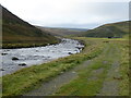
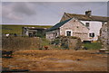
1
The River Tees, Widdy Bank Farm and Widdybank Fell
Image: © Mike Quinn
Taken: 3 Aug 2007
0.01 miles
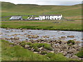
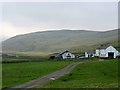
3
Widdybank farm, Upper Teesdale
A well-known reference point on the Pennine Way, as walkers head up the River Tees towards Cauldron Snout and then on to High Cup Nick.
Image: © Uncredited
Taken: 27 Apr 2005
0.01 miles
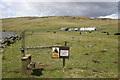
4
Public convenience provided at Widdy Bank Farm for walkers on the Pennine Way
Image: © Peter Robinson
Taken: Unknown
0.01 miles
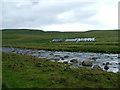
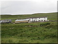
5
Widdy Bank Farm
View towards Widdybank Fell with the stream of Fold Sike cutting diagonally down past the small huts in the distance to join the River Tees.
Image: © Andrew Curtis
Taken: 30 Apr 2004
0.02 miles
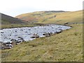
7
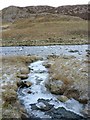
Icy Wildscar Sike debouches into the Tees below Cronkley Scar
Despite appearances, this was a sunny day with a high enough air temperature that walking in a fleece jacket was a bit hot. However, even just after midday, the low winter sun doesn't reach this bit of the river, and the last bit of Wildscar Sike remains in the shade of Cronkley Scar. The frozen ground makes for less squelchy walking than is typical in warmer weather, though there are some icy rocks to negotiate along the river bank, so care is essential on this stretch of the Pennine Way.
Image: © Andy Waddington
Taken: 20 Jan 2011
0.08 miles
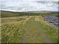
8
Pennine Way by Widdybank Farm
Looking up the River Tees with the hillside of Widdy Bank to the right.
Image: © Oliver Dixon
Taken: 30 Nov 2016
0.09 miles
9
Pennine Way approaching Widdy Bank Farm
The view for southbound walkers as they near Widdy Bank Farm beside the River Tees - although the trail stays outside the perimeter of the buildings having been rerouted, probably to give privacy.
Image: © Chris Heaton
Taken: 7 Sep 2009
0.15 miles