IMAGES TAKEN NEAR TO
Forest In Teesdale, BARNARD CASTLE, DL12 0EL
Introduction
This page details the photographs taken nearby to DL12 0EL by members of the Geograph project.
The Geograph project started in 2005 with the aim of publishing, organising and preserving representative images for every square kilometre of Great Britain, Ireland and the Isle of Man.

There are currently over 7.5m images from over14,400 individuals and you can help contribute to the project by visiting https://www.geograph.org.uk
Image Map
Images are licensed for reuse under creativecommons.org/licenses/by-sa/2.0
Notes
- Clicking on the map will re-center to the selected point.
- The higher the marker number, the further away the image location is from the centre of the postcode.
Image Listing (37 Images Found)
Images are licensed for reuse under creativecommons.org/licenses/by-sa/2.0
Image
Details
Distance
1
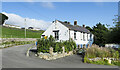
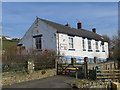
School at Forest-in-Teesdale
The school building is close to the Hanging Shaw car park just off the B6277 in Teesdale. The school has a very small roll and so in January 2021 it 'federated' with other similarly small ones - Rookhope, St John’s Chapel and Wearhead Primary Schools as the Upper Durham Dales Federation, all under one headteacher. There was no activity at the school on this day; autumn term would begin on 6 September in 2021.
Image: © Trevor Littlewood
Taken: 2 Sep 2021
0.08 miles
4
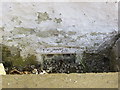
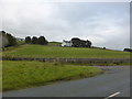
Ordnance Survey Flush Bracket S8156
This partially buried bracket can be found on the wall of the school at Forest-in-Teesdale. The benchmark height is recorded as being 383.24 metres above sea level.
Image: © Peter Wood
Taken: 26 Mar 2017
0.08 miles
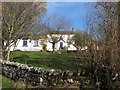
5
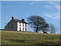
Forest of Teesdale School
Looking eastward.
Image: © Peter Wood
Taken: 26 Mar 2017
0.08 miles

10
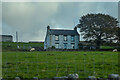
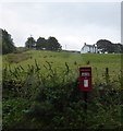
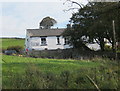
Forest and Frith : Grassy Field
Looking towards Dale House.
Image: © Lewis Clarke
Taken: 25 Sep 2020
0.08 miles