IMAGES TAKEN NEAR TO
Eggleston, BARNARD CASTLE, DL12 0DW
Introduction
This page details the photographs taken nearby to DL12 0DW by members of the Geograph project.
The Geograph project started in 2005 with the aim of publishing, organising and preserving representative images for every square kilometre of Great Britain, Ireland and the Isle of Man.

There are currently over 7.5m images from over14,400 individuals and you can help contribute to the project by visiting https://www.geograph.org.uk
Image Map
Images are licensed for reuse under creativecommons.org/licenses/by-sa/2.0
Notes
- Clicking on the map will re-center to the selected point.
- The higher the marker number, the further away the image location is from the centre of the postcode.
Image Listing (7 Images Found)
Images are licensed for reuse under creativecommons.org/licenses/by-sa/2.0
Image
Details
Distance
1
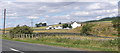
Pallet Crag
On the B6279 Moor Lane, close to several disused quarries.
Image: © Hugh Mortimer
Taken: 28 Jul 2006
0.01 miles
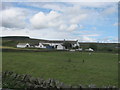
4
Pallet Crag Farm
Standing close to the B6279. Stobgreen Plantation Image in the background.
Image: © Oliver Dixon
Taken: 4 Jun 2009
0.01 miles
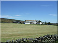
6

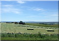
Grassy slope of field near to Moor Head
The field is on the north side of the B6279 near to its meeting with the B6278. The gated entry into the field is set back from the road and the gate itself is festooned with barbed wire... a defence against what?
Image: © Trevor Littlewood
Taken: 25 Dec 2016
0.21 miles
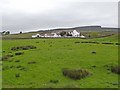
7
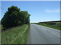
B6279 towards Staindrop
Looking south east.
Image: © JThomas
Taken: 25 Jun 2018
0.24 miles