IMAGES TAKEN NEAR TO
Eggleston, BARNARD CASTLE, DL12 0DS
Introduction
This page details the photographs taken nearby to DL12 0DS by members of the Geograph project.
The Geograph project started in 2005 with the aim of publishing, organising and preserving representative images for every square kilometre of Great Britain, Ireland and the Isle of Man.

There are currently over 7.5m images from over14,400 individuals and you can help contribute to the project by visiting https://www.geograph.org.uk
Image Map
Images are licensed for reuse under creativecommons.org/licenses/by-sa/2.0
Notes
- Clicking on the map will re-center to the selected point.
- The higher the marker number, the further away the image location is from the centre of the postcode.
Image Listing (4 Images Found)
Images are licensed for reuse under creativecommons.org/licenses/by-sa/2.0
Image
Details
Distance
1
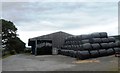
Agricultural Buildings at West Barnley Farm
Image: © Anthony Parkes
Taken: 28 Jun 2014
0.02 miles
3
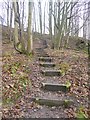
Teesdale Way in Great Wood
A flight of steps carries the left-bank branch of the Teesdale Way from river level up to the pastures above.
Image: © Oliver Dixon
Taken: 6 Feb 2017
0.22 miles
4
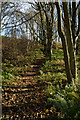
Teesdale Way rising through Great Wood
The path rises obliquely across the slope on which Great Wood grows, the way being stepped with timbers retaining earth to ease passage and minimise erosion.
Image: © Trevor Littlewood
Taken: 22 Nov 2013
0.24 miles