IMAGES TAKEN NEAR TO
Town Head, BARNARD CASTLE, DL12 0DF
Introduction
This page details the photographs taken nearby to Town Head, DL12 0DF by members of the Geograph project.
The Geograph project started in 2005 with the aim of publishing, organising and preserving representative images for every square kilometre of Great Britain, Ireland and the Isle of Man.

There are currently over 7.5m images from over14,400 individuals and you can help contribute to the project by visiting https://www.geograph.org.uk
Image Map
Images are licensed for reuse under creativecommons.org/licenses/by-sa/2.0
Notes
- Clicking on the map will re-center to the selected point.
- The higher the marker number, the further away the image location is from the centre of the postcode.
Image Listing (11 Images Found)
Images are licensed for reuse under creativecommons.org/licenses/by-sa/2.0
Image
Details
Distance
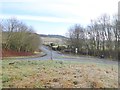
1
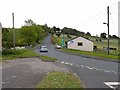
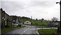
Road junction, Eggleston
Unusually, six B roads converge on Eggleston, although they do not all meet at one point - the B6278 Barnard Castle to Stanhope road intersects the B6282 Bishop Auckland to Middleton-in-Teesdale road; also converging on Eggleston are the B6279 from Darlington and the B6281 from Mickleton. This image shows Folly Bank designated as the B6278, but also carrying the B6282 for a short distance. Lowson's Garage Centre stands by the road.
Image: © Oliver Dixon
Taken: 4 Jun 2009
0.01 miles
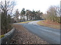
2
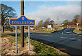
Junction of B classified roads outside Eggleston
The B6282 and the B6278 meet just east of the County Durham village of Eggleston. The blue and yellow road sign is characteristic of a style of signage introduced by County Durham some years ago.
Image: © Trevor Littlewood
Taken: 1 Jan 2013
0.01 miles
3
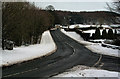
Eggleston
The B6282 passing through Eggleston.
Image: © Peter McDermott
Taken: 26 Dec 2009
0.02 miles
4
Eggleston : Moor Lane B6282
Looking along the B6282.
Image: © Lewis Clarke
Taken: 25 Sep 2020
0.03 miles
5
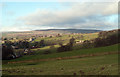
Fields above B6278 near Eggleston
Eggleston with the B6278 can be seen at the left side of the image; the fields lie above the road on its north side. The distant high ground rises to Monk's Moor.
Image: © Trevor Littlewood
Taken: 12 Dec 2011
0.10 miles
6
Eggleston : Moor Lane B6282
Looking along Moor Lane.
Image: © Lewis Clarke
Taken: 25 Sep 2020
0.10 miles
7
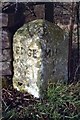
Old Milestone by the B6282, Eggleston
Carved stone post by the B6282, in parish of EGGLESTON (TEESDALE District), 50m East of Stobgreen Sike, under hedge, opposite brown sign for Eggleston Gardens, on North side of road. Edge stone, erected by the Eggleston Coal Road turnpike trust in the 19th century.
Inscription reads:-
: EDGE / 5½ : : MIDN / 4 :
Grade II Listed. List Entry Number:1121633
https://historicengland.org.uk/listing/the-list/list-entry/1121633
Milestone Society National ID: DU_MTEG04.
Image: © C Minto & IA Davison
Taken: 27 Oct 2004
0.14 miles
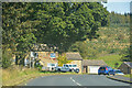
8
Folly Bank : Eggleston
Looking south to Barnard Castle, Gatehouse on the left, Lowsons Garage centre.
Image: © Hugh Mortimer
Taken: 28 Feb 2007
0.17 miles
9
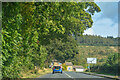
Road junction at Eggleston
To the left and away from the camera the B6282 Middleton to Copley road; to the right the B6281 which crosses the Tees to Mickleton. See also Image for a view of another junction a short way to the north.
Image: © Oliver Dixon
Taken: 6 Feb 2017
0.20 miles
10
Road Junction near Eggleston
This photograph shows a view of the junction between the B6282 road (from where the picture was taken) and the B6281 road to Mickleton (going off to the left). The picture was taken looking in a south-westerly direction towards Eggleston Hall.
Image: © Philip Barker
Taken: 14 Mar 2010
0.21 miles