IMAGES TAKEN NEAR TO
Eggleston, BARNARD CASTLE, DL12 0AP
Introduction
This page details the photographs taken nearby to DL12 0AP by members of the Geograph project.
The Geograph project started in 2005 with the aim of publishing, organising and preserving representative images for every square kilometre of Great Britain, Ireland and the Isle of Man.

There are currently over 7.5m images from over14,400 individuals and you can help contribute to the project by visiting https://www.geograph.org.uk
Image Map
Images are licensed for reuse under creativecommons.org/licenses/by-sa/2.0
Notes
- Clicking on the map will re-center to the selected point.
- The higher the marker number, the further away the image location is from the centre of the postcode.
Image Listing (5 Images Found)
Images are licensed for reuse under creativecommons.org/licenses/by-sa/2.0
Image
Details
Distance
1
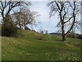
Old plough strips at Eggleston
There's a mass of old cultivation terraces marked on the OS map to the west of Eggleston village, but those on the steeper hillsides are by far the best preserved and most prominent.
Image: © Gordon Hatton
Taken: 25 Mar 2016
0.02 miles
2
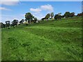
Cultivation Terraces at Eggleston
Well preserved cultivation terraces to the west of Eggleston village.
Image: © Clive Nicholson
Taken: 18 Sep 2020
0.11 miles
3
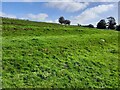
Cultivation Terraces at Eggleston
Well preserved cultivation terraces to the west of Eggleston village.
Image: © Clive Nicholson
Taken: 18 Sep 2020
0.14 miles
4
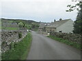
Quiet lane north of Eggleston.
A walk in Teesdale.
Image: © steven ruffles
Taken: 19 May 2022
0.16 miles
5
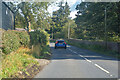
Eggleston : B6282
Heading along the B6282.
Image: © Lewis Clarke
Taken: 25 Sep 2020
0.24 miles