IMAGES TAKEN NEAR TO
Baldwin Lane, DARLINGTON, DL1 1QA
Introduction
This page details the photographs taken nearby to Baldwin Lane, DL1 1QA by members of the Geograph project.
The Geograph project started in 2005 with the aim of publishing, organising and preserving representative images for every square kilometre of Great Britain, Ireland and the Isle of Man.

There are currently over 7.5m images from over14,400 individuals and you can help contribute to the project by visiting https://www.geograph.org.uk
Image Map
Images are licensed for reuse under creativecommons.org/licenses/by-sa/2.0
Notes
- Clicking on the map will re-center to the selected point.
- The higher the marker number, the further away the image location is from the centre of the postcode.
Image Listing (8 Images Found)
Images are licensed for reuse under creativecommons.org/licenses/by-sa/2.0
Image
Details
Distance
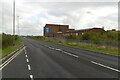
4

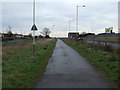
Footpath on the route of the Stockton to Darlington Railway
A very ordinary looking footpath on the route of the world's first passenger railway, looking east near Red Hall.
Image: © Alan Fearon
Taken: 16 Feb 2006
0.19 miles
6
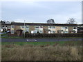
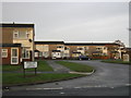
McMullan Road, Darlington.
Car dealerships located on McMullan Road on the 11th September 2006.
Image: © Philip Soakell
Taken: 11 Sep 2006
0.20 miles
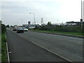
7
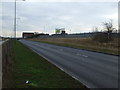
Darlington Eastern transport Corridor near Lingfield Point
Image: © Mark Anderson
Taken: 17 Oct 2020
0.20 miles