IMAGES TAKEN NEAR TO
Hurst, RICHMOND, DL11 7NL
Introduction
This page details the photographs taken nearby to DL11 7NL by members of the Geograph project.
The Geograph project started in 2005 with the aim of publishing, organising and preserving representative images for every square kilometre of Great Britain, Ireland and the Isle of Man.

There are currently over 7.5m images from over14,400 individuals and you can help contribute to the project by visiting https://www.geograph.org.uk
Image Map
Images are licensed for reuse under creativecommons.org/licenses/by-sa/2.0
Notes
- Clicking on the map will re-center to the selected point.
- The higher the marker number, the further away the image location is from the centre of the postcode.
Image Listing (4 Images Found)
Images are licensed for reuse under creativecommons.org/licenses/by-sa/2.0
Image
Details
Distance
1
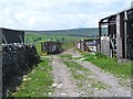
Bridleway and barns
These rather tatty barns appear to be outbuildings for nearby High Greenas Farm on the bridleway from Skelton towards Hurst.
Image: © Gordon Hatton
Taken: 12 Jul 2015
0.08 miles
3
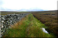
Soggy bridleway across Skelton Moor
It's one of those tracks where, with a bit of agility, one can keep one's feet out of all the puddles and soft ground, but where rain in the last half hour has left enough water clinging to the Juncus effusus that it is hardly worth the effort - just accept that wet feet go with the territory.
Image: © Andy Waddington
Taken: 10 Jul 2020
0.22 miles
4
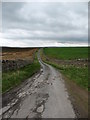
Helwith Road near High Greenas.
A quiet dead end lane which must have once taken travellers through to Helwith, but which now only allows vehicles as far as the entrance to High Greenas farm.
Image: © Gordon Hatton
Taken: 24 Apr 2007
0.22 miles