IMAGES TAKEN NEAR TO
Dalton, RICHMOND, DL11 7HE
Introduction
This page details the photographs taken nearby to DL11 7HE by members of the Geograph project.
The Geograph project started in 2005 with the aim of publishing, organising and preserving representative images for every square kilometre of Great Britain, Ireland and the Isle of Man.

There are currently over 7.5m images from over14,400 individuals and you can help contribute to the project by visiting https://www.geograph.org.uk
Image Map
Images are licensed for reuse under creativecommons.org/licenses/by-sa/2.0
Notes
- Clicking on the map will re-center to the selected point.
- The higher the marker number, the further away the image location is from the centre of the postcode.
Image Listing (6 Images Found)
Images are licensed for reuse under creativecommons.org/licenses/by-sa/2.0
Image
Details
Distance
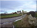
1
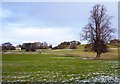
Dunsa Manor from Little Lane
Dunsa Manor overlooks south-facing slopes northwest of Ravensworth, dropping down to a track, Little Lane, which carries a public footpath forming part of a walking route from Dalton to West Layton. The fastigiate beech tree on the right caught my eye as having an immense amount of witch's broom low in its crown. It's not clear how it has attracted all those rocks to cluster round the base of the trunk.
Image: © Andy Waddington
Taken: 26 Nov 2010
0.10 miles
3
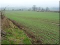
Farmland north of Dunsa Manor
A long, relatively narrow field on the west side of Dick Scot Lane.
Image: © Christine Johnstone
Taken: 13 Feb 2017
0.15 miles
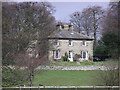
5
Sikelands Farm from Little Lane
The road down past Dunsa Manor and Sikelands Farm rejoices in the name Dick Scot Lane. Here it turns a sharp corner, where a bridleway leads south across open fields and a track, Little Lane, leads east as a public footpath, whose signpost is seen here.
Image: © Andy Waddington
Taken: 26 Nov 2010
0.20 miles
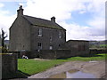
6
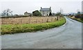
Looking north to Sikelands Farm
On the west side of Dock Scot Lane, below Dunsa Bank.
Image: © Christine Johnstone
Taken: 13 Feb 2017
0.20 miles