IMAGES TAKEN NEAR TO
Eppleby, RICHMOND, DL11 7BH
Introduction
This page details the photographs taken nearby to DL11 7BH by members of the Geograph project.
The Geograph project started in 2005 with the aim of publishing, organising and preserving representative images for every square kilometre of Great Britain, Ireland and the Isle of Man.

There are currently over 7.5m images from over14,400 individuals and you can help contribute to the project by visiting https://www.geograph.org.uk
Image Map
Images are licensed for reuse under creativecommons.org/licenses/by-sa/2.0
Notes
- Clicking on the map will re-center to the selected point.
- The higher the marker number, the further away the image location is from the centre of the postcode.
Image Listing (19 Images Found)
Images are licensed for reuse under creativecommons.org/licenses/by-sa/2.0
Image
Details
Distance
1
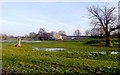
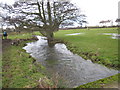
Mill Farm over Forcett Beck
At this level, all the snow has melted (apart from the odd snowplough-built piles at the sides or the road), but the resulting meltwater has not drained from the fields. You can just discern Forcett Beck, almost bank full as it flows through the very flat fields between Eppleby just to the north and the fortifications of Stanwick St. John to the south.
Image: © Andy Waddington
Taken: 11 Dec 2010
0.02 miles
2
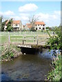
Forcett Beck
Although the houses in the background are in the village of Eppleby, this is still just within Forcett parish, thus the name given to the beck. Some head scratching needed here if following the public footpath northwards as it isn't well signed. The map suggests a line straight across the beck, but this would invite problems with a marshy area, lack of bridge and fencing. The line is actually across this farm bridge and thence to a field gate in the far corner of the next field.
Image: © Gordon Hatton
Taken: 29 Apr 2019
0.02 miles
3
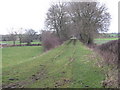
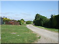
Disused railway track near Eppleby
This photograph shows part of the disused railway track that ran between Forcett Valley and Darlington. The section shown here runs up the east side of the small village of Eppleby. Some of the stone boundary walls of properties in the village can be seen on the left-hand side of the picture. This section of the old railway is now used as a farm access track.
Image: © Philip Barker
Taken: 13 Dec 2009
0.06 miles
4
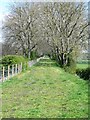
Old railway track, Forcett
The situation is much closer to Eppleby than Forcett, but this is still within the parish of the latter village. The line was once used for transportation of limestone from the nearby Forcett quarries.
Image: © Gordon Hatton
Taken: 29 Apr 2019
0.08 miles
6
Forcett Beck in spate near Eppleby
This photograph shows an unusually high level of water in Forcett Beck as it flows in a north-easterly direction towards the village of Eppleby. Some of the houses at the south end of the village can just be seen in the right-hand side of the picture.
Image: © Philip Barker
Taken: 13 Dec 2009
0.09 miles
7
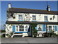
Track behind the Cross Keys
Leading towards the dismantled railway.
Image: © Stanley Howe
Taken: 5 Jun 2007
0.10 miles
9
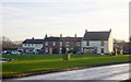
Eppleby on a winter afternoon
Eppleby's village green is L-shaped, as seen from above. This view is from the road that cuts down the middle of the upright of the "L", across the horizontal, which leads off east of the road, and down to the pub.
Image: © Andy Waddington
Taken: 11 Dec 2010
0.13 miles
10
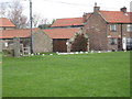
The village green at Eppleby
This photograph shows a view of part of the village green at Eppleby looking in an easterly direction from the incoming public footpath from Caldwell (to the west).
Image: © Philip Barker
Taken: 13 Dec 2009
0.15 miles