IMAGES TAKEN NEAR TO
RICHMOND, DL11 7AF
Introduction
This page details the photographs taken nearby to DL11 7AF by members of the Geograph project.
The Geograph project started in 2005 with the aim of publishing, organising and preserving representative images for every square kilometre of Great Britain, Ireland and the Isle of Man.

There are currently over 7.5m images from over14,400 individuals and you can help contribute to the project by visiting https://www.geograph.org.uk
Image Map
Images are licensed for reuse under creativecommons.org/licenses/by-sa/2.0
Notes
- Clicking on the map will re-center to the selected point.
- The higher the marker number, the further away the image location is from the centre of the postcode.
Image Listing (4 Images Found)
Images are licensed for reuse under creativecommons.org/licenses/by-sa/2.0
Image
Details
Distance
1
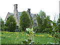
Carlton Green Farm
With an impressive array of chimneys. Currently up for sale.
Image: © Oliver Dixon
Taken: 29 Apr 2014
0.02 miles
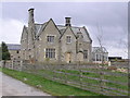
3
Carlton Green Farmhouse near Aldbrough St John
Image: © Peter Robinson
Taken: 16 Feb 2012
0.04 miles
4
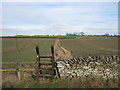
Footpath north from minor road to the east of Brickkiln Lane
Image: © Peter Robinson
Taken: 16 Feb 2012
0.24 miles