IMAGES TAKEN NEAR TO
Reeth, RICHMOND, DL11 6TF
Introduction
This page details the photographs taken nearby to DL11 6TF by members of the Geograph project.
The Geograph project started in 2005 with the aim of publishing, organising and preserving representative images for every square kilometre of Great Britain, Ireland and the Isle of Man.

There are currently over 7.5m images from over14,400 individuals and you can help contribute to the project by visiting https://www.geograph.org.uk
Image Map
Images are licensed for reuse under creativecommons.org/licenses/by-sa/2.0
Notes
- Clicking on the map will re-center to the selected point.
- The higher the marker number, the further away the image location is from the centre of the postcode.
Image Listing (287 Images Found)
Images are licensed for reuse under creativecommons.org/licenses/by-sa/2.0
Image
Details
Distance
1
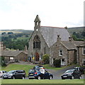
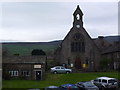
Reeth Congregational Church
Grade-II listed from around 1866: http://www.britishlistedbuildings.co.uk/en-322289-congregational-church-reeth-fremington-a#.VbN5usvbKmQ . Swaledale is rich in nonconformist chapels, which were set up to provide spiritual solace to lead miners (see: http://www.martinroe.pwp.blueyonder.co.uk/ ) and their families, which the established church seemed unwilling or unable to support.
Image: © Bill Harrison
Taken: 5 Jul 2015
0.01 miles
2
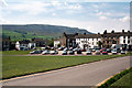
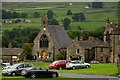
Reeth, Swaledale, Yorkshire
The village of Reeth is an attractive place to stop if you are motoring through Swaledale. There are three pubs where you can get lunch, and a small folk museum which is worth a visit. At busy times, it is not always easy to find a parking place.
Image: © Dr Neil Clifton
Taken: 16 May 2002
0.01 miles
5
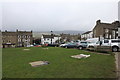
Pottery and Church....
....on the village green in Reeth.
Image: © John H Darch
Taken: 4 May 2014
0.02 miles
6
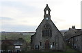
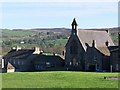
Reeth Evangelical Congregational Church
Located at the south end of the village green
Image: © Chris Heaton
Taken: 25 Nov 2017
0.02 miles
7
![Reeth houses [3]](https://s2.geograph.org.uk/geophotos/07/29/88/7298834_1d8e2120_120x120.jpg)
Reeth houses [3]
Numbers 1, 2 and 3 are three houses in a terrace. Built in the late 18th century of coursed rubble stone under a stone slate roof. Numbers 1 and 2 share a porch. Listed, grade II, with details at: https://historicengland.org.uk/listing/the-list/list-entry/1131504
Reeth is a village, some 8½ miles west of Richmond, set on a plateau above the River Swale, surrounded by hills and moors. At the junction of roads up Swaledale and Arkengarthdale, Reeth was an important service centre for the lead mines and smelt mills based in these two valleys in the 18th and 19th centuries. Now a centre for walkers and other visitors to the Yorkshire Dales National Park.
Image: © Michael Dibb
Taken: 20 Jun 2022
0.02 miles
8
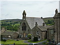
![Reeth buildings [8]](https://s0.geograph.org.uk/geophotos/07/29/88/7298868_2e4e0ef5_120x120.jpg)
Reeth buildings [8]
The Congregational Church, Market Place, was built in 1866. Constructed of squared, coursed stone under a Welsh slate roof. Listed, for group value, grade II, with details at: https://historicengland.org.uk/listing/the-list/list-entry/1318274
Reeth is a village, some 8½ miles west of Richmond, set on a plateau above the River Swale, surrounded by hills and moors. At the junction of roads up Swaledale and Arkengarthdale, Reeth was an important service centre for the lead mines and smelt mills based in these two valleys in the 18th and 19th centuries. Now a centre for walkers and other visitors to the Yorkshire Dales National Park.
Image: © Michael Dibb
Taken: 20 Jun 2022
0.02 miles
9
Reeth Evangelical Congregational Church
Image: © Alexander P Kapp
Taken: 24 Jun 2011
0.02 miles
10
Reeth Evangelical Congregational Church
Image: © Steve Daniels
Taken: 28 Jul 2011
0.02 miles