IMAGES TAKEN NEAR TO
Arkengarthdale, RICHMOND, DL11 6RR
Introduction
This page details the photographs taken nearby to DL11 6RR by members of the Geograph project.
The Geograph project started in 2005 with the aim of publishing, organising and preserving representative images for every square kilometre of Great Britain, Ireland and the Isle of Man.

There are currently over 7.5m images from over14,400 individuals and you can help contribute to the project by visiting https://www.geograph.org.uk
Image Map
Images are licensed for reuse under creativecommons.org/licenses/by-sa/2.0
Notes
- Clicking on the map will re-center to the selected point.
- The higher the marker number, the further away the image location is from the centre of the postcode.
Image Listing (6 Images Found)
Images are licensed for reuse under creativecommons.org/licenses/by-sa/2.0
Image
Details
Distance
1
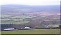
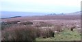
Hill Top Farm
From this vantage point, Hill Top Farm looks more like 'Dale Bottom farm' as it is a long way down the slope. Arkle Beck can be seen beyond with Park Farm in the distance. The fells beyond are shrouded in mist.
Image: © Gordon Hatton
Taken: 20 Nov 2010
0.01 miles
2
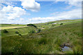
River Arkle below Hilltop Farm
Throughout Arkengarthdale, tractors were busily at work turning, rowing or baling the hay - one field seen in this view has already been finished and its bales collected whilst a tractor is turning hay in a field on the right behind the small barn. Newly cut or turned fields are full of Lapwings and Starlings, whilst gulls join them to follow the machinery. The River Arkle, nestling in its valley below all this activity, is very low, but with heavy rain, can be paddled from some way upstream of here and for some way below before trees start to become a serious hazard. With even more rain, as happened in July 2019, it can burst its banks and evidence is everywhere of footbridges and walls swept away and workmen rebuilding walls and bridges. There will be several more months of work before all the footpaths are reopened.
Image: © Andy Waddington
Taken: 21 Jul 2020
0.10 miles
3
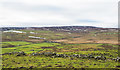
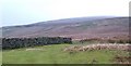
Ruined wall crossing rough grazing
The enclosed area of rough grazing is on the north side of Arkengarthdale. The view beyond is across the valley to a moorland high point at West Moor which rises to finally to Water Crag.
Image: © Trevor Littlewood
Taken: 26 Jan 2018
0.19 miles
4
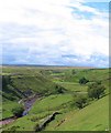
Arkle Beck
Arkengarthdale is not typical in its landforms. Instead of the beck rising on some steep and impressive fellside, it begins in a rather featureless area of boggy moorland somewhere between Tan Hill and Stainmoor, only becoming a more typical dale further downstream. These are the upper reaches of Arkle Beck near Hill Top Farm.
Image: © Gordon Hatton
Taken: 29 Jul 2010
0.21 miles
5
Path to Ravens Park
Footpath across some rather wet ground above the intake wall. Ravens Park farm can be seen in the misty distance.
Image: © Gordon Hatton
Taken: 20 Nov 2010
0.24 miles
6
Colt Park Corner
The abrupt change of direction of the field head wall at this point is marked as Colt Park Corner on the 1:25000 map. Beyond is a mist shrouded Cleasby Hill.
Image: © Gordon Hatton
Taken: 20 Nov 2010
0.25 miles