IMAGES TAKEN NEAR TO
High Lane, RICHMOND, DL11 6NS
Introduction
This page details the photographs taken nearby to High Lane, DL11 6NS by members of the Geograph project.
The Geograph project started in 2005 with the aim of publishing, organising and preserving representative images for every square kilometre of Great Britain, Ireland and the Isle of Man.

There are currently over 7.5m images from over14,400 individuals and you can help contribute to the project by visiting https://www.geograph.org.uk
Image Map
Images are licensed for reuse under creativecommons.org/licenses/by-sa/2.0
Notes
- Clicking on the map will re-center to the selected point.
- The higher the marker number, the further away the image location is from the centre of the postcode.
Image Listing (12 Images Found)
Images are licensed for reuse under creativecommons.org/licenses/by-sa/2.0
Image
Details
Distance
1
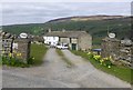
Drovers House
On the minor road from Swaledale to Wensleydale.
Looking down to Feetham across the River Swale.
Image: © Russel Wills
Taken: 11 Apr 2019
0.01 miles
2
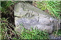
Benchmark on rock by gateway for Bushes House
Ordnance Survey rivet benchmark described on the Bench Mark Database at http://www.bench-marks.org.uk/bm78551
Image: © Roger Templeman
Taken: 7 Sep 2016
0.07 miles
3
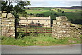
Gateway to field of Bushes House
There is an OS benchmark Image on the rock in front of the right hand gate pier
Image: © Roger Templeman
Taken: 7 Sep 2016
0.07 miles
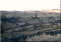
4
Replanting above Low Lane
Recent maps still show a conifer plantation on this slope. It appears to have been felled and replanted.
Image: © Stephen Craven
Taken: 7 May 2024
0.11 miles
5
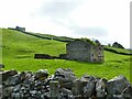
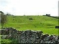
Ruined laithe above Low Lane
This one has long since lost its roof but the walls remain standing to full height, which has enabled trees to grow within its shelter. It has an attached walled enclosure, perhaps as a sheepfold.
Image: © Stephen Craven
Taken: 7 May 2024
0.15 miles
7
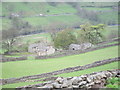
Feetham Holme Cottages
Beautifully situated self-catering cottages overlooking Swaledale, and well off the beaten track.
Image: © Peter Whitcomb
Taken: 12 May 2013
0.16 miles
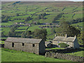
9
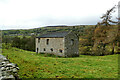
Substantial field barn below Low Lane
Perched on a terrace south of the River Swale, just above a section of floodplain known as "Sand Beds", this is a very substantial barn in good condition - no sagging of the roof beam or failure of walls as in so many now-disused barns in the area.
Image: © Andy Waddington
Taken: 17 Nov 2020
0.18 miles
10
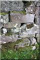
Benchmark on stone in wall of High Lane
Ordnance Survey cut mark benchmark described on the Bench Mark Database at http://www.bench-marks.org.uk/bm79644
Image: © Roger Templeman
Taken: 7 Sep 2016
0.22 miles