IMAGES TAKEN NEAR TO
Tunstall, RICHMOND, DL10 7RD
Introduction
This page details the photographs taken nearby to DL10 7RD by members of the Geograph project.
The Geograph project started in 2005 with the aim of publishing, organising and preserving representative images for every square kilometre of Great Britain, Ireland and the Isle of Man.

There are currently over 7.5m images from over14,400 individuals and you can help contribute to the project by visiting https://www.geograph.org.uk
Image Map
Images are licensed for reuse under creativecommons.org/licenses/by-sa/2.0
Notes
- Clicking on the map will re-center to the selected point.
- The higher the marker number, the further away the image location is from the centre of the postcode.
Image Listing (2 Images Found)
Images are licensed for reuse under creativecommons.org/licenses/by-sa/2.0
Image
Details
Distance
1
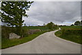
Track to Cote House Farm
Nicely tarmacked. Sign appears home made.
Image: © Tony Simms
Taken: 20 May 2015
0.10 miles
2
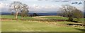
View East from Hillcrest, SE185944
The vale of York and the North Yorkshire Moors beyond, Northallerton in centre of frame approx 15km distant
Image: © Bill Oakes
Taken: 6 Apr 2004
0.18 miles