IMAGES TAKEN NEAR TO
Elm Walk, RICHMOND, DL10 7PB
Introduction
This page details the photographs taken nearby to Elm Walk, DL10 7PB by members of the Geograph project.
The Geograph project started in 2005 with the aim of publishing, organising and preserving representative images for every square kilometre of Great Britain, Ireland and the Isle of Man.

There are currently over 7.5m images from over14,400 individuals and you can help contribute to the project by visiting https://www.geograph.org.uk
Image Map
Images are licensed for reuse under creativecommons.org/licenses/by-sa/2.0
Notes
- Clicking on the map will re-center to the selected point.
- The higher the marker number, the further away the image location is from the centre of the postcode.
Image Listing (7 Images Found)
Images are licensed for reuse under creativecommons.org/licenses/by-sa/2.0
Image
Details
Distance
1
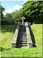
War Memorial beside Leeming Lane, Catterick
Image: © JThomas
Taken: 24 Jul 2020
0.15 miles
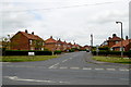
2
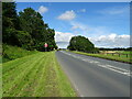
Leeming Lane, Catterick
Towards Catterick Bridge.
Image: © JThomas
Taken: 24 Jul 2020
0.15 miles
4
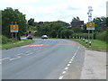
Approach to Catterick from the north
Image: © Richard Dawson
Taken: 27 Jul 2007
0.16 miles
5
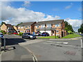
Mowbray Road, Catterick
The entrance to a quite extensive housing estate which has been added to several times over the years.
Image: © Tony Simms
Taken: 27 May 2015
0.18 miles