IMAGES TAKEN NEAR TO
Great North Road, RICHMOND, DL10 7JN
Introduction
This page details the photographs taken nearby to Great North Road, DL10 7JN by members of the Geograph project.
The Geograph project started in 2005 with the aim of publishing, organising and preserving representative images for every square kilometre of Great Britain, Ireland and the Isle of Man.

There are currently over 7.5m images from over14,400 individuals and you can help contribute to the project by visiting https://www.geograph.org.uk
Image Map
Images are licensed for reuse under creativecommons.org/licenses/by-sa/2.0
Notes
- Clicking on the map will re-center to the selected point.
- The higher the marker number, the further away the image location is from the centre of the postcode.
Image Listing (9 Images Found)
Images are licensed for reuse under creativecommons.org/licenses/by-sa/2.0
Image
Details
Distance
1
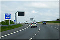
Variable Message (Matrix) Sign on the A1(M) near to Brompton-on-Swale
A variable message sign on the northbound carriageway of the A1M in North Yorkshire.
Variable message signs (VMS), also sometimes referred to as matrix signs, are electronic traffic signs used on motorways (and some other major routes) to give drivers information about special events and to warn them about traffic congestion, accidents, incidents, roadworks or speed limits on specific sections of the route. They may also suggest (or instruct) drivers to take alternative routes, limit speed, warn of duration and location of the incidents or just inform of the traffic conditions.
Image: © David Dixon
Taken: 29 Apr 2019
0.09 miles
2

Bungalow next to the A1 northbound at Woodside
Image: © Peter Robinson
Taken: 21 Aug 2013
0.13 miles
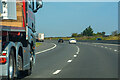
4
A1
The Southbound A1 Trunk Road to the North of Catterick Bridge.
Image: © Peter McDermott
Taken: 3 Jul 2014
0.17 miles
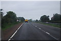
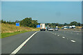
5
Brompton-on-Swale : A1(M)
Looking north on the A1(M).
Image: © Lewis Clarke
Taken: 21 Sep 2020
0.22 miles
6
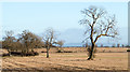
Stubble field with trees
The field lies to the east of the A1 trunk road. It was recorded from beside a stationary vehicle on the south-bound carriageway - an accident ahead delayed travel for two and a half hours! The stretch of road is being upgraded to motorway standard which is causing disruption anyway. The camera location as recorded by GPS appears to be marginally off the road: perhaps the realignment of road surfaces has already gone beyond what current OS mapping shows.
Image: © Trevor Littlewood
Taken: 11 Dec 2015
0.23 miles
7
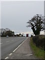
Oak Grange
Looking south along the A1 towards Catterick.
Image: © Andy Farrington
Taken: 6 Apr 2012
0.23 miles
8
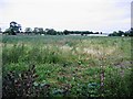
Rough Pasture
Rough Pasture next to the A1
Image: © Graham Scarborough
Taken: 2 Sep 2007
0.24 miles
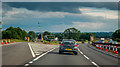
9
Moulton : A1(M)
Looking north on the A1(M).
Image: © Lewis Clarke
Taken: 21 Sep 2020
0.25 miles