IMAGES TAKEN NEAR TO
Middleton Tyas, RICHMOND, DL10 6RE
Introduction
This page details the photographs taken nearby to DL10 6RE by members of the Geograph project.
The Geograph project started in 2005 with the aim of publishing, organising and preserving representative images for every square kilometre of Great Britain, Ireland and the Isle of Man.

There are currently over 7.5m images from over14,400 individuals and you can help contribute to the project by visiting https://www.geograph.org.uk
Image Map
Images are licensed for reuse under creativecommons.org/licenses/by-sa/2.0
Notes
- Clicking on the map will re-center to the selected point.
- The higher the marker number, the further away the image location is from the centre of the postcode.
Image Listing (65 Images Found)
Images are licensed for reuse under creativecommons.org/licenses/by-sa/2.0
Image
Details
Distance
1
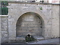
Village Well : Middleton Tyas
This well has a biblical inscription; John 4:13.'Whosoever drinketh of this water' etc.
Image: © Hugh Mortimer
Taken: 7 Aug 2006
0.02 miles
2
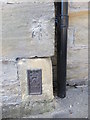
Middleton Tyas, Cow Lane
There is a benchmark cut into the road facing wall of Rookery Gardens. It is to the left of the joint between the roadside wall and the house.
Image: © Mel Towler
Taken: 8 Apr 2022
0.02 miles
3
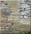
Middleton Tyas, Cow Lane
The benchmark is cut into the road facing wall of Rookery Gardens.
Image: © Mel Towler
Taken: 8 Apr 2022
0.02 miles
4
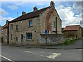
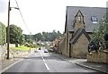
School Bank, Middleton Tyas
Steep main street in this attractive village. The house on the right is the old School House, renamed "Unnamed House" Image
Image: © Oliver Dixon
Taken: 23 Aug 2013
0.02 miles
5
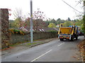
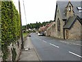
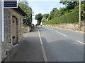
Skip lorry on The Strand
A skip lorry heads south on the Strand.
Image: © Maigheach-gheal
Taken: 24 Oct 2011
0.03 miles
6
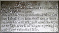
Text, Tumbling Well
The biblical text that is inscribed on a marble tablet within the well shown in Image
Image: © Maigheach-gheal
Taken: 24 Oct 2011
0.03 miles
7
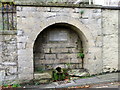
Tumbling Well, Middleton Tyas
The mid 19th century surround to the well is of ashlar while the spout and trough dates from the 18th century. The marble slab is inscribed with a biblical text.
Image: © Maigheach-gheal
Taken: 24 Oct 2011
0.03 miles
9
School Bank at Unnamed House in Middleton Tyas
Looking westward.
Image: © Peter Wood
Taken: 15 Jul 2015
0.05 miles
10
Ordnance Survey Flush Bracket 2178
This can be found on the roadside wall of a former school building - now a private dwelling - in Middleton Tyas.
For more detail see : http://www.bench-marks.org.uk/bm10211
Image: © Peter Wood
Taken: 15 Jul 2015
0.05 miles