IMAGES TAKEN NEAR TO
Waterfall Terrace, RICHMOND, DL10 6LZ
Introduction
This page details the photographs taken nearby to Waterfall Terrace, DL10 6LZ by members of the Geograph project.
The Geograph project started in 2005 with the aim of publishing, organising and preserving representative images for every square kilometre of Great Britain, Ireland and the Isle of Man.

There are currently over 7.5m images from over14,400 individuals and you can help contribute to the project by visiting https://www.geograph.org.uk
Image Map
Images are licensed for reuse under creativecommons.org/licenses/by-sa/2.0
Notes
- Clicking on the map will re-center to the selected point.
- The higher the marker number, the further away the image location is from the centre of the postcode.
Image Listing (7 Images Found)
Images are licensed for reuse under creativecommons.org/licenses/by-sa/2.0
Image
Details
Distance
1
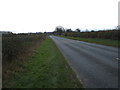
Minor road out of Barton
Heading south west towards Junction 56, A1(M) Motorway.
Image: © JThomas
Taken: 14 Nov 2015
0.12 miles
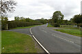
2
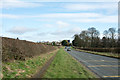
Minor road heading towards Barton
The road has climbed away from the roundabout at junction 56 on the A1(M) and is heading north-west towards Barton.
Image: © Trevor Littlewood
Taken: 5 Mar 2017
0.15 miles
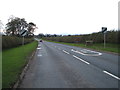
4
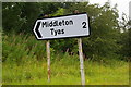
Sign to Middleton Tyas, south of Barton
Image: © Christopher Hilton
Taken: 24 Aug 2012
0.19 miles
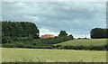
7
Kneeton Lane
Near the entrance to North Road Farm.
Image: © Mark Anderson
Taken: 17 Oct 2020
0.24 miles