IMAGES TAKEN NEAR TO
Barton, RICHMOND, DL10 6HP
Introduction
This page details the photographs taken nearby to DL10 6HP by members of the Geograph project.
The Geograph project started in 2005 with the aim of publishing, organising and preserving representative images for every square kilometre of Great Britain, Ireland and the Isle of Man.

There are currently over 7.5m images from over14,400 individuals and you can help contribute to the project by visiting https://www.geograph.org.uk
Image Map
Images are licensed for reuse under creativecommons.org/licenses/by-sa/2.0
Notes
- Clicking on the map will re-center to the selected point.
- The higher the marker number, the further away the image location is from the centre of the postcode.
Image Listing (8 Images Found)
Images are licensed for reuse under creativecommons.org/licenses/by-sa/2.0
Image
Details
Distance
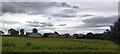
2
Clowbeck Farm
Taken from Farm access bridge
Image: © Hugh Mortimer
Taken: 17 Mar 2006
0.10 miles
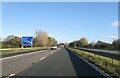
4
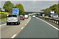
A1(M) approaching Blackwell Spur Interchange
Approaching Junction 57, the interchange with the western end of the A66(M) to Darlington.
Image: © David Dixon
Taken: 29 Apr 2019
0.14 miles
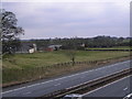
5
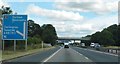
Approaching junction 57 on the A1(M)
Image: © Anthony Parkes
Taken: 11 Aug 2018
0.19 miles
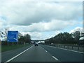
6
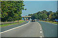
Newton Morrell : A1(M)
Looking north on the A1(M).
Image: © Lewis Clarke
Taken: 21 Sep 2020
0.20 miles
7
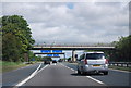
Approaching junction 57, A1(M)
The beginning of the A66(M).
Image: © N Chadwick
Taken: 29 May 2011
0.22 miles