IMAGES TAKEN NEAR TO
Newton Morrell, RICHMOND, DL10 6HJ
Introduction
This page details the photographs taken nearby to DL10 6HJ by members of the Geograph project.
The Geograph project started in 2005 with the aim of publishing, organising and preserving representative images for every square kilometre of Great Britain, Ireland and the Isle of Man.

There are currently over 7.5m images from over14,400 individuals and you can help contribute to the project by visiting https://www.geograph.org.uk
Image Map
Images are licensed for reuse under creativecommons.org/licenses/by-sa/2.0
Notes
- Clicking on the map will re-center to the selected point.
- The higher the marker number, the further away the image location is from the centre of the postcode.
Image Listing (9 Images Found)
Images are licensed for reuse under creativecommons.org/licenses/by-sa/2.0
Image
Details
Distance
2
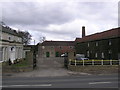
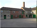
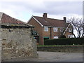
Newton Morrell : Farm
Large estate farm, with buildings around a yard.
Image: © Hugh Mortimer
Taken: 4 Apr 2006
0.08 miles
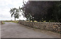
7
The old Great North Road near the entrance to South Farm
Image: © Mark Anderson
Taken: 17 Oct 2020
0.17 miles
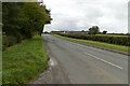
8
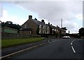
Once the A1
Before the construction of the nearby A1(M) motorway, this was the route of the single carriageway A1 which headed into Darlington. Now downgraded to an unclassified road, it is an alternative to the A66(M) from north of Scotch Corner to Darlington.
Image: © Gordon Hatton
Taken: 9 May 2021
0.22 miles
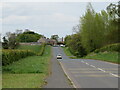
9
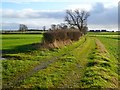
Track and farmland, Newton Morrell
Public bridleway with arable fields and pasture to the northwest of the hamlet.
Image: © Andrew Smith
Taken: 3 Dec 2011
0.25 miles