IMAGES TAKEN NEAR TO
Ellerton Upon Swale, RICHMOND, DL10 6BG
Introduction
This page details the photographs taken nearby to DL10 6BG by members of the Geograph project.
The Geograph project started in 2005 with the aim of publishing, organising and preserving representative images for every square kilometre of Great Britain, Ireland and the Isle of Man.

There are currently over 7.5m images from over14,400 individuals and you can help contribute to the project by visiting https://www.geograph.org.uk
Image Map
Images are licensed for reuse under creativecommons.org/licenses/by-sa/2.0
Notes
- Clicking on the map will re-center to the selected point.
- The higher the marker number, the further away the image location is from the centre of the postcode.
Image Listing (7 Images Found)
Images are licensed for reuse under creativecommons.org/licenses/by-sa/2.0
Image
Details
Distance
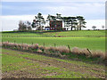
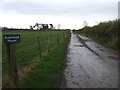
3
Track to Rushwood Farm
The farmhouse is part concealed by the trees on the left.
Image: © Gordon Hatton
Taken: 29 Apr 2021
0.09 miles
7
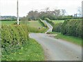
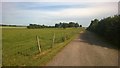
Minor road towards Forest
Looking east along the road with the entrance to Rushwood Farm on the right.
Image: © Gordon Hatton
Taken: 29 Apr 2021
0.20 miles