IMAGES TAKEN NEAR TO
Moor Road, RICHMOND, DL10 5PG
Introduction
This page details the photographs taken nearby to Moor Road, DL10 5PG by members of the Geograph project.
The Geograph project started in 2005 with the aim of publishing, organising and preserving representative images for every square kilometre of Great Britain, Ireland and the Isle of Man.

There are currently over 7.5m images from over14,400 individuals and you can help contribute to the project by visiting https://www.geograph.org.uk
Image Map
Images are licensed for reuse under creativecommons.org/licenses/by-sa/2.0
Notes
- Clicking on the map will re-center to the selected point.
- The higher the marker number, the further away the image location is from the centre of the postcode.
Image Listing (9 Images Found)
Images are licensed for reuse under creativecommons.org/licenses/by-sa/2.0
Image
Details
Distance
1
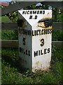
Old Milepost, Moor Road, Melsonby
Cast iron post, in parish of MELSONBY (RICHMONDSHIRE District), South end of Melsonby village, on the verge outside southernmost cottage, on East side of road. Bedale HD iron casting, erected by the Local Highways Board in the 19th/20th century.
Inscription reads:-
: {hand->} / RICHMOND / 5 / MILES : : RICHMOND / H.D : : {<-hand} / LUCY.CROSS / 3 / MILES :
Maker:-
: F MATTISON & Co / BEDALE :
Milestone Society National ID: YN_RCLX05
Image: © C Minto
Taken: 18 May 2010
0.02 miles
2
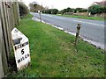
Old Milepost, Moor Road, Melsonby
Cast iron post in parish of Melsonby (Richmondshire District), South end of Melsonby village, on the verge outside southernmost cottage, on East side of road. Bedale HD iron casting, erected by the Local Highways Board in the 19th/20th century.
Inscription reads:-
: {hand->} / RICHMOND / 5 / MILES : : RICHMOND / H.D : : {<-hand} / LUCY.CROSS / 3 / MILES :
Maker:-
: F MATTISON & Co / BEDALE :
Milestone Society National ID: YN_RCLX05
Image: © Hilary Jones
Taken: 23 Nov 2023
0.02 miles
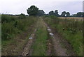
3
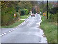
Moor Road, Melsonby
Looking back towards Melsonby from the spot height 167m.
Image: © Mick Garratt
Taken: 6 Nov 2005
0.06 miles
5
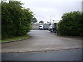
An HGV transport depot, Melsonby
United Pallet Network (UPN) site.
Image: © Stanley Howe
Taken: 14 Aug 2010
0.12 miles
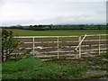
6
Dicky Dobbin Lane
Looking west to Moor Road, Melsonby.
Image: © Hugh Mortimer
Taken: 19 Aug 2006
0.16 miles
7
Jagger Lane
Jagger Lane is one of the oldest named routes in the country. At this point in Melsonby it currently has the status of a private road, but it continues variously as a byway, a bridleway and a public road, on its way to old lead mines at Hartforth and beyond towards Swaledale.
Image: © Andy Waddington
Taken: 30 Oct 2020
0.18 miles
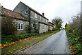
9
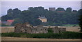
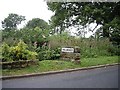
Glebe Farm (Ruin)
The ruin of Glebe Farm from the end of Dicky Dobbin Lane. With St.James the Great Church, Melsonby in the background.
Image: © Hugh Mortimer
Taken: 19 Aug 2006
0.21 miles