IMAGES TAKEN NEAR TO
High Row, RICHMOND, DL10 5LZ
Introduction
This page details the photographs taken nearby to High Row, DL10 5LZ by members of the Geograph project.
The Geograph project started in 2005 with the aim of publishing, organising and preserving representative images for every square kilometre of Great Britain, Ireland and the Isle of Man.

There are currently over 7.5m images from over14,400 individuals and you can help contribute to the project by visiting https://www.geograph.org.uk
Image Map
Images are licensed for reuse under creativecommons.org/licenses/by-sa/2.0
Notes
- Clicking on the map will re-center to the selected point.
- The higher the marker number, the further away the image location is from the centre of the postcode.
Image Listing (59 Images Found)
Images are licensed for reuse under creativecommons.org/licenses/by-sa/2.0
Image
Details
Distance
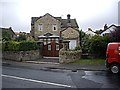
1
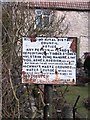
Don't drop anything!
A rather forbidding old notice in Melsonby, dated 1906.
Image: © Gordon Hatton
Taken: 14 Mar 2010
0.03 miles
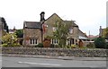
2
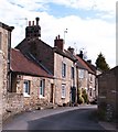
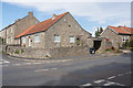
Cottages in Melsonby
A row of 18th and 19th century cottages in Melsonby. Use of sandstone, limestone and rubble for construction here.
Image: © Gordon Hatton
Taken: 14 Mar 2010
0.03 miles
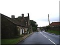
5
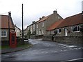
A house on the corner of West Road, Melsonby
Image: © Stanley Howe
Taken: 14 Aug 2010
0.04 miles
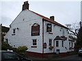
8
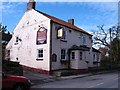
The Black Bull
Melsonby's village pub.
Image: © Gordon Hatton
Taken: 14 Mar 2010
0.06 miles
10
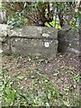
OS Cut Mark: Melsonby, Bridge
https://www.bench-marks.org.uk/bm174086
Image: © thejackrustles
Taken: 21 Sep 2022
0.06 miles