IMAGES TAKEN NEAR TO
Gilling West, RICHMOND, DL10 5LN
Introduction
This page details the photographs taken nearby to DL10 5LN by members of the Geograph project.
The Geograph project started in 2005 with the aim of publishing, organising and preserving representative images for every square kilometre of Great Britain, Ireland and the Isle of Man.

There are currently over 7.5m images from over14,400 individuals and you can help contribute to the project by visiting https://www.geograph.org.uk
Image Map
Images are licensed for reuse under creativecommons.org/licenses/by-sa/2.0
Notes
- Clicking on the map will re-center to the selected point.
- The higher the marker number, the further away the image location is from the centre of the postcode.
Image Listing (4 Images Found)
Images are licensed for reuse under creativecommons.org/licenses/by-sa/2.0
Image
Details
Distance
1
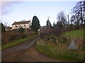
Sedbury Park Farm, Gilling West, near Richmond, North Yorkshire
Image: © Oliver Dixon
Taken: 19 Dec 2005
0.04 miles
2
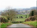
Road to Gilling West
Minor road heading north west towards Gilling West.
Image: © Gordon Hatton
Taken: 29 Dec 2019
0.13 miles
3
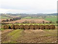
Straw bales near Sedbury Park Farm
The bales appear to be rather green on top, so maybe they have been here sometime. The view is south west across the valley of Gilling Beck.
Image: © Gordon Hatton
Taken: 29 Dec 2019
0.18 miles
4
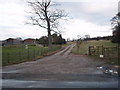
Cattlegrid and entrance to Carrbeck House
This photograph shows a view of the entrance to Carrbeck House from the minor road that connects Gilling west and Skeeby Grange. The picture was taken looking in a north-easterly direction towards Sedbury Park.
Image: © Philip Barker
Taken: 13 Feb 2010
0.25 miles