IMAGES TAKEN NEAR TO
Hartforth, Gilling West, RICHMOND, DL10 5JZ
Introduction
This page details the photographs taken nearby to DL10 5JZ by members of the Geograph project.
The Geograph project started in 2005 with the aim of publishing, organising and preserving representative images for every square kilometre of Great Britain, Ireland and the Isle of Man.

There are currently over 7.5m images from over14,400 individuals and you can help contribute to the project by visiting https://www.geograph.org.uk
Image Map
Images are licensed for reuse under creativecommons.org/licenses/by-sa/2.0
Notes
- Clicking on the map will re-center to the selected point.
- The higher the marker number, the further away the image location is from the centre of the postcode.
Image Listing (7 Images Found)
Images are licensed for reuse under creativecommons.org/licenses/by-sa/2.0
Image
Details
Distance
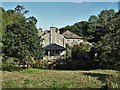
2
Lane to Hartforth Saw Mill
Now a bed and breakfast establishment.
Image: © Mick Garratt
Taken: 20 Apr 2011
0.03 miles
3
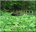
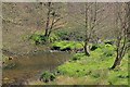
Footbridge over Hartforth Beck
Luxuriant plant growth makes the bridge hard to photograph. Just downstream from Hartforth Mill, now a private house, but marked on old OS maps as a corn mill, and later as a saw mill.
Image: © Gordon Hatton
Taken: 25 May 2015
0.05 miles
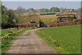
6
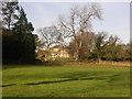
Hartforth Hill, near Richmond, North Yorkshire
Shown on the map as Hartforth Grange
Image: © Oliver Dixon
Taken: 19 Dec 2005
0.19 miles
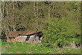
7
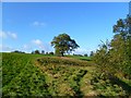
Pasture, Whashton
A footpath follows the edge of this field alongside woodland and Hartforth Beck.
Image: © Andrew Smith
Taken: 18 Oct 2011
0.23 miles