IMAGES TAKEN NEAR TO
Green Howards Road, RICHMOND, DL10 4TX
Introduction
This page details the photographs taken nearby to Green Howards Road, DL10 4TX by members of the Geograph project.
The Geograph project started in 2005 with the aim of publishing, organising and preserving representative images for every square kilometre of Great Britain, Ireland and the Isle of Man.

There are currently over 7.5m images from over14,400 individuals and you can help contribute to the project by visiting https://www.geograph.org.uk
Image Map
Images are licensed for reuse under creativecommons.org/licenses/by-sa/2.0
Notes
- Clicking on the map will re-center to the selected point.
- The higher the marker number, the further away the image location is from the centre of the postcode.
Image Listing (114 Images Found)
Images are licensed for reuse under creativecommons.org/licenses/by-sa/2.0
Image
Details
Distance
1
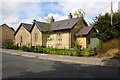
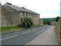
#23 Green Howards Road
The former wall in front of this former hospital has been replaced by a metal fence
Image: © Roger Templeman
Taken: 18 Aug 2016
0.04 miles
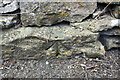
2
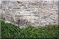
Benchmark on former barracks, Beechfield Road
Ordnance Survey cut mark benchmark described on the Bench Mark Database at http://www.bench-marks.org.uk/bm44983
Image: © Roger Templeman
Taken: 23 Aug 2012
0.05 miles
3
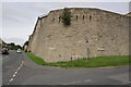
Former barracks at junction of Beechfield Road and Galloway
There is an OS benchmark Image on the corner of the building
Image: © Roger Templeman
Taken: 23 Aug 2012
0.05 miles
4
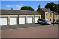
Block of garages, Haakon Close
The houses were built in 2001 following demolition of previous buildings on the site
Image: © Roger Templeman
Taken: 17 Aug 2016
0.05 miles
5
Richmondshire Leisure Centre, Gallowgate
Image: © Mick Garratt
Taken: 26 Jul 2005
0.07 miles
6
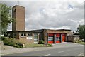
Richmond fire station
Richmond fire station, Gallowgate, Richmond, North Yorkshire
Image: © Kevin Hale
Taken: 3 Aug 2010
0.08 miles
7
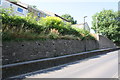
Raised pavement and stone wall on west side of Gallowgate
There is an OS benchmark Image on a stone in the wall below the 2nd drainage hole from the left hand edge of the image
Image: © Roger Templeman
Taken: 17 Aug 2016
0.09 miles
8
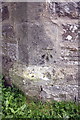
Benchmark on tower at Gallowgate entrance to former barracks
Ordnance Survey cut mark benchmark described on the Bench Mark Database at http://www.bench-marks.org.uk/bm44131
Image: © Roger Templeman
Taken: 23 Aug 2012
0.09 miles
9
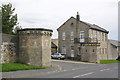
Entrance towers to former barracks, Gallowgate
There is an OS benchmark Image at the left edge of the middle face of the near tower
Image: © Roger Templeman
Taken: 23 Aug 2012
0.09 miles
10
Benchmark on wall stone beside path opposite #38 Alexandra Way
Ordnance Survey pivot benchmark described on the Bench Mark Database at http://www.bench-marks.org.uk/bm78088
Image: © Roger Templeman
Taken: 18 Aug 2016
0.11 miles