IMAGES TAKEN NEAR TO
Chantry Mews, RICHMOND, DL10 4QD
Introduction
This page details the photographs taken nearby to Chantry Mews, DL10 4QD by members of the Geograph project.
The Geograph project started in 2005 with the aim of publishing, organising and preserving representative images for every square kilometre of Great Britain, Ireland and the Isle of Man.

There are currently over 7.5m images from over14,400 individuals and you can help contribute to the project by visiting https://www.geograph.org.uk
Image Map (Loading...)


Getting Data...Please wait
Leaflet Map data © OpenStreetMap
Images are licensed for reuse under creativecommons.org/licenses/by-sa/2.0
Notes
- Clicking on the map will re-center to the selected point.
- The higher the marker number, the further away the image location is from the centre of the postcode.
Image Listing (1017 Images Found)
Images are licensed for reuse under creativecommons.org/licenses/by-sa/2.0
Image
Details
Distance
1
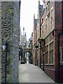
Friars Wynd
This narrow lane gave access from the Market Place to the Franciscan Friary. The postern gate one of few remaining sections of the 14th century town wall let the inhabitants collect drinking water from the Friary spring.
The tram lines were laid by ironmonger Robert Spence. The tramway ran from the market place where heavy goods brought from Richmond station by horse and cart were off loaded onto the rails trolley and pushed by 2 men to his warehouse. The warehouse is now the Georgian Theatre Museum.
(This information was taken from signs posted in the passage).
Image: © Graham Hogg
Taken: 15 May 2013
0.01 miles
2
![Richmond features [52]](https://s0.geograph.org.uk/geophotos/07/32/25/7322560_d1b7e714_120x120.jpg)
Richmond features [52]
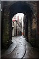
In Friars Wynd, is this semicircular stone archway set in a fragment of the original Town Walls. Constructed circa 1312, part of the original postern gate. Listed, grade II, with details at: https://historicengland.org.uk/listing/the-list/list-entry/1131212
Richmond is a picturesque market town in North Yorkshire, some 13 miles northwest of Northallerton and about 11½ miles southwest of Darlington. Set on the north bank of the River Swale, the town is on the edge of the Yorkshire Dales National Park, and is marketed as the Gateway to the Dales. Richmond was founded in 1071 and the castle was completed in 1086. Tourism is important to the local economy, as is the influence of the nearby Catterick Garrison army base. A traditional market operates every Saturday in the large cobbled marketplace.
Image: © Michael Dibb
Taken: 21 Jun 2022
0.01 miles
3
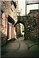
Friar's Wynd, Richmond
The gateway shown here dates from c.1312 and formed part of the Postern Gate in the medieval town wall. It is grade II listed (list entry 1131212). The rails set into the ground are much later (19th century), see Image for a detailed explanation and a view from the other side.
Image: © Stephen Craven
Taken: 26 Oct 1994
0.01 miles
4
![Richmond buildings [57]](https://s0.geograph.org.uk/geophotos/07/32/25/7322552_9b773d3e_120x120.jpg)
Richmond buildings [57]
Numbers 6, 8 and 10 Finkle Street were built in the late 18th or early 19th century. Constructed of rendered rubble stone under a stone slate roof. Number 10 has a small 19th century shopfront and a yard door on the right. Numbers 6 and 8 have two late 19th century and one modern shopfronts. Listed, grade II, with details at: https://historicengland.org.uk/listing/the-list/list-entry/1131229
Richmond is a picturesque market town in North Yorkshire, some 13 miles northwest of Northallerton and about 11½ miles southwest of Darlington. Set on the north bank of the River Swale, the town is on the edge of the Yorkshire Dales National Park, and is marketed as the Gateway to the Dales. Richmond was founded in 1071 and the castle was completed in 1086. Tourism is important to the local economy, as is the influence of the nearby Catterick Garrison army base. A traditional market operates every Saturday in the large cobbled marketplace.
Image: © Michael Dibb
Taken: 19 Jun 2022
0.01 miles
6
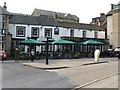
The Turf Hotel
One of many pubs in and around Richmond town centre. This one faces out on to the corner of Victoria Road and Queen's Road and is built roughly on the line of the former town wall.
Image: © Gordon Hatton
Taken: 25 Sep 2008
0.01 miles
7
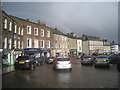
Rainbow over Richmond Market Place
Image: © Jonathan Thacker
Taken: 21 Feb 2014
0.01 miles
8
![Richmond buildings [59]](https://s2.geograph.org.uk/geophotos/07/32/25/7322554_1e7cc389_120x120.jpg)
Richmond buildings [59]
The Black Lion public house, number 12 Finkle Street, was built in the 18th century. Constructed of painted, rendered rubble stone under a slate roof. The early 19th century entrance has Tuscan stone engaged columns and a cornice. Listed, grade II, with details at: https://historicengland.org.uk/listing/the-list/list-entry/1318417
Richmond is a picturesque market town in North Yorkshire, some 13 miles northwest of Northallerton and about 11½ miles southwest of Darlington. Set on the north bank of the River Swale, the town is on the edge of the Yorkshire Dales National Park, and is marketed as the Gateway to the Dales. Richmond was founded in 1071 and the castle was completed in 1086. Tourism is important to the local economy, as is the influence of the nearby Catterick Garrison army base. A traditional market operates every Saturday in the large cobbled marketplace.
Image: © Michael Dibb
Taken: 19 Jun 2022
0.02 miles
9
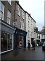
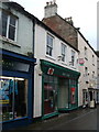
The Black Lion, Richmond
Front entrance on Finkle Street.
Image: © JThomas
Taken: 14 Nov 2015
0.02 miles