IMAGES TAKEN NEAR TO
Ryders Wynd, RICHMOND, DL10 4JA
Introduction
This page details the photographs taken nearby to Ryders Wynd, DL10 4JA by members of the Geograph project.
The Geograph project started in 2005 with the aim of publishing, organising and preserving representative images for every square kilometre of Great Britain, Ireland and the Isle of Man.

There are currently over 7.5m images from over14,400 individuals and you can help contribute to the project by visiting https://www.geograph.org.uk
Image Map (Loading...)


Getting Data...Please wait
Leaflet Map data © OpenStreetMap
Images are licensed for reuse under creativecommons.org/licenses/by-sa/2.0
Notes
- Clicking on the map will re-center to the selected point.
- The higher the marker number, the further away the image location is from the centre of the postcode.
Image Listing (949 Images Found)
Images are licensed for reuse under creativecommons.org/licenses/by-sa/2.0
Image
Details
Distance
1
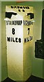
Old Milepost in Richmondshire Museum, Ryders Wynd, Richmond
Cast iron post, was on B6274, in parish of FORCETT AND CARKIN (RICHMONDSHIRE District), was 1 mile South of Forcett, now in the Richmondshire Museum, Ryders Wynd, Richmond. Bedale HD iron casting, erected by the Local Highways Board in the 19th/20th century.
Inscription reads:- : {pointing hand} / STAINDROP / 8 / MILES : : RICHMOND / H.D : : {pointing hand} / RICHMOND / 7 / MILES :
Milestone Society National ID: YN_RCSP07.
Image: © IT
Taken: 6 Sep 2008
0.02 miles
2
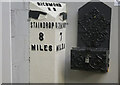
Old Milepost in Richmondshire Museum, Ryders Wynd, Richmond
Cast iron post, was on B6274, in parish of FORCETT AND CARKIN (RICHMONDSHIRE District), was 1 mile South of Forcett, now in the Richmondshire Museum, Ryders Wynd, Richmond. Bedale HD iron casting, erected by the Local Highways Board in the 19th/20th century.
Inscription reads:- : {pointing hand} / STAINDROP / 8 / MILES : : RICHMOND / H.D : : {pointing hand} / RICHMOND / 7 / MILES :
Milestone Society National ID: YN_RCSP07.
Image: © Simon Green
Taken: 10 Oct 2023
0.02 miles
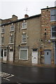
3

CB Furnishings, Queen's Road
Furnishing shop in what was once a local cinema.
Image: © Gordon Hatton
Taken: 25 Sep 2008
0.03 miles
4
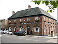
The Ralph Fitzrandal public house
Large drinking establishment on Queen's Road. If it looks rather like a 1930's post office, it is because it was once the head post office in the town before conversion to a pub. [PO now in Finkle Street]
Image: © Gordon Hatton
Taken: 25 Sep 2008
0.03 miles
5
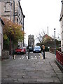
Ryder's Wynd, Richmond
A feature of Richmond is the number of back alleys and side streets known as 'wynds'. Ryder's Wynd leads from Frenchgate towards the tower of Greyfriars.
Image: © Gordon Hatton
Taken: 25 Nov 2007
0.03 miles
6
![Richmond houses [35]](https://s1.geograph.org.uk/geophotos/07/27/79/7277905_aa449a9a_120x120.jpg)
Richmond houses [35]
The Grove, number 37 Frenchgate, was built in 1750 with a later one bay extension on the left. Set back from the road and constructed of red brick with stone quoins and dressings under a slate roof. There are two large semicircular bow windows, probably early 19th century. Listed, grade II*, with details at: https://historicengland.org.uk/listing/the-list/list-entry/1318419
Richmond is a picturesque market town in North Yorkshire, some 13 miles northwest of Northallerton and about 11½ miles southwest of Darlington. Set on the north bank of the River Swale, the town is on the edge of the Yorkshire Dales National Park, and is marketed as the Gateway to the Dales. Richmond was founded in 1071 and the castle was completed in 1086. Tourism is important to the local economy, as is the influence of the nearby Catterick Garrison army base. A traditional market operates every Saturday in the large cobbled marketplace.
Image: © Michael Dibb
Taken: 18 Jun 2022
0.03 miles
7
Buildings on Frenchgate
The house in the middle of the image (#27) has an OS benchmark Image on a wall stone at pavement level to the right of the white door
Image: © Roger Templeman
Taken: 21 Aug 2012
0.04 miles
8
![Richmond houses [30]](https://s3.geograph.org.uk/geophotos/07/27/78/7277891_64e91450_120x120.jpg)
Richmond houses [30]
Number 31A Frenchgate was built in the late 18th century. Constructed of roughcast rubble stone under a slate roof. Listed, grade II, with details at: https://historicengland.org.uk/listing/the-list/list-entry/1131240
Richmond is a picturesque market town in North Yorkshire, some 13 miles northwest of Northallerton and about 11½ miles southwest of Darlington. Set on the north bank of the River Swale, the town is on the edge of the Yorkshire Dales National Park, and is marketed as the Gateway to the Dales. Richmond was founded in 1071 and the castle was completed in 1086. Tourism is important to the local economy, as is the influence of the nearby Catterick Garrison army base. A traditional market operates every Saturday in the large cobbled marketplace.
Image: © Michael Dibb
Taken: 18 Jun 2022
0.04 miles
9
![Richmond houses [31]](https://s1.geograph.org.uk/geophotos/07/27/78/7277893_f0fcc54e_120x120.jpg)
Richmond houses [31]
Numbers 31 and 35 Frenchgate were built in the mid 18th century. Constructed of rubble stone, stuccoed and lined to simulate ashlar, under a stone slate roof. Listed, grade II, with details at: https://historicengland.org.uk/listing/the-list/list-entry/1131240
Richmond is a picturesque market town in North Yorkshire, some 13 miles northwest of Northallerton and about 11½ miles southwest of Darlington. Set on the north bank of the River Swale, the town is on the edge of the Yorkshire Dales National Park, and is marketed as the Gateway to the Dales. Richmond was founded in 1071 and the castle was completed in 1086. Tourism is important to the local economy, as is the influence of the nearby Catterick Garrison army base. A traditional market operates every Saturday in the large cobbled marketplace.
Image: © Michael Dibb
Taken: 18 Jun 2022
0.04 miles
10
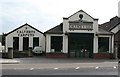
Calverts Carpets, Queen's Road
Carpet emporium based in a former Ford garage on Queen's Road.
Image: © Gordon Hatton
Taken: 25 Sep 2008
0.04 miles