IMAGES TAKEN NEAR TO
Milltop, RICHMOND, DL10 4EA
Introduction
This page details the photographs taken nearby to Milltop, DL10 4EA by members of the Geograph project.
The Geograph project started in 2005 with the aim of publishing, organising and preserving representative images for every square kilometre of Great Britain, Ireland and the Isle of Man.

There are currently over 7.5m images from over14,400 individuals and you can help contribute to the project by visiting https://www.geograph.org.uk
Image Map
Images are licensed for reuse under creativecommons.org/licenses/by-sa/2.0
Notes
- Clicking on the map will re-center to the selected point.
- The higher the marker number, the further away the image location is from the centre of the postcode.
Image Listing (34 Images Found)
Images are licensed for reuse under creativecommons.org/licenses/by-sa/2.0
Image
Details
Distance
1
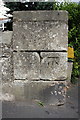
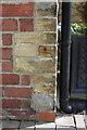
Benchmark on corner wall pier of #59 Reeth Road
Ordnance Survey cut mark benchmark described on the Bench Mark Database at http://www.bench-marks.org.uk/bm44970
Image: © Roger Templeman
Taken: 23 Aug 2012
0.02 miles
2
Junction of Fieldings Yard with Reeth Road
There is an OS benchmark Image on the corner wall pier.
Image: © Roger Templeman
Taken: 23 Aug 2012
0.03 miles
4
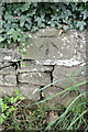
Benchmark on wall on south side of Reeth Road
Ordnance Survey cut mark benchmark described on the Bench Mark Database at http://www.bench-marks.org.uk/bm44968
Image: © Roger Templeman
Taken: 23 Aug 2012
0.05 miles
5
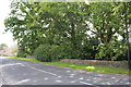
Reeth Road (A6108)
There is an OS benchmark Image on the stone wall, opposite house #69
Image: © Roger Templeman
Taken: 23 Aug 2012
0.05 miles
6
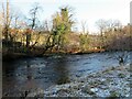
The Swale above Richmond Bridge
A frosty January morning by the Swale around 1km upstream from Richmond Bridge.
Image: © Gordon Hatton
Taken: 5 Jan 2022
0.08 miles
7
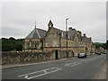
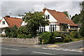
Former school of the Assumption
A former school and convent run by the Religious Order of the Assumption. Building began in 1851 and the school closed in 1993. Now apartments.
Image: © Jonathan Thacker
Taken: 26 Jun 2014
0.10 miles
8
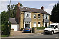
#35 Reeth Road
There is an OS benchmark Image on the side of the house, on the front left corner.
Image: © Roger Templeman
Taken: 23 Aug 2012
0.15 miles
9
Benchmark on #35 Reeth Road
Ordnance Survey cut mark benchmark described on the Bench Mark Database at http://www.bench-marks.org.uk/bm44973
Image: © Roger Templeman
Taken: 23 Aug 2012
0.15 miles
10
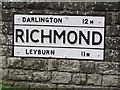
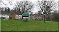
Old Village Signpost by the A6108, Reeth Road, Richmond
No finial - by the A6108, in parish of Richmond (Richmondshire District), Reeth Road, Richmond. At junction with Coronation Place, on grass verge, set in plinth, North side of road.
Surveyed
Milestone Society National ID: YN_NZ1501
Image: © K Hackett
Taken: 11 Oct 2017
0.15 miles