IMAGES TAKEN NEAR TO
Rose Crescent, RICHMOND, DL10 4DA
Introduction
This page details the photographs taken nearby to Rose Crescent, DL10 4DA by members of the Geograph project.
The Geograph project started in 2005 with the aim of publishing, organising and preserving representative images for every square kilometre of Great Britain, Ireland and the Isle of Man.

There are currently over 7.5m images from over14,400 individuals and you can help contribute to the project by visiting https://www.geograph.org.uk
Image Map
Images are licensed for reuse under creativecommons.org/licenses/by-sa/2.0
Notes
- Clicking on the map will re-center to the selected point.
- The higher the marker number, the further away the image location is from the centre of the postcode.
Image Listing (41 Images Found)
Images are licensed for reuse under creativecommons.org/licenses/by-sa/2.0
Image
Details
Distance
1
#1 Quarry Road
There is an Ordnance Survey cut mark benchmark http://www.bench-marks.org.uk/bm44978 on the corner of the house hidden behind a wooden post
Image: © Roger Templeman
Taken: 23 Aug 2012
0.04 miles
2
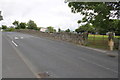
Quarry Road
There is an OS benchmark Image on the far gatepost
Image: © Roger Templeman
Taken: 23 Aug 2012
0.07 miles
3
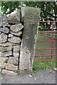
Benchmark on Quarry Road gatepost
Ordnance Survey cut mark benchmark described on the Bench Mark Database at http://www.bench-marks.org.uk/bm44977
Image: © Roger Templeman
Taken: 23 Aug 2012
0.07 miles
4
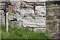
Benchmark on the wall of #24 Hurgill Road
Ordnance Survey cut mark benchmark described on the Bench Mark Database at http://www.bench-marks.org.uk/bm44979
Image: © Roger Templeman
Taken: 23 Aug 2012
0.08 miles
5
#24 Hurgill Road
There is an OS benchmark Image on the wall corner to the left of the steps
Image: © Roger Templeman
Taken: 23 Aug 2012
0.08 miles
6
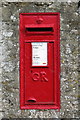
GR Postbox, Richmond
Box number DL10 42, on Hurgill Road near the junction of Quarry Road.
Image: © David Rogers
Taken: 14 Oct 2009
0.09 miles
7
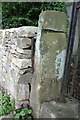
Benchmark on gatepost, Hurgill Road
Ordnance Survey cut mark benchmark described on the Bench Mark Database at http://www.bench-marks.org.uk/bm44980
Image: © Roger Templeman
Taken: 23 Aug 2012
0.09 miles
8
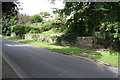
Hurgill Road
There is an OS benchmark Image on the left hand side gatepost beside the matal gate at the right hand side of the image
Image: © Roger Templeman
Taken: 23 Aug 2012
0.09 miles
9
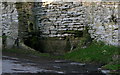
Hurgill Trough
Water trough on Hurgill Road, in the 1850's spelled Hergill.
Image: © David Rogers
Taken: 10 Mar 2009
0.10 miles
10
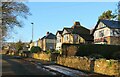
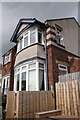
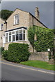
Houses on Westfields
Desirable properties on Westfields in Richmond, most likely dating from the period between the wars.
Image: © Gordon Hatton
Taken: 5 Jan 2022
0.15 miles